A Bad Time On The Roads · Manatee County
Tampa Bay Area master map — Hillsborough, Pinellas & Manatee combined.
Is now a bad time to drive in Bradenton?
Saved only in your browser.
Live feed shows official trouble in Manatee County. Weekly FDOT seasonal factors for Manatee County aren't on this page yet. The badge follows today's live FDOT incidents (refreshed every 5 minutes). AADT map below is from FDOT 2025 counts.
Live right now
0 incidents · 32 full road closures · 0 signal issues · 4 scheduled road work in Manatee County.
36 pins for incidents / full closures / signals (verdict drivers). Red = Bad · Amber = Meh. Closures without coordinates stay in the list.
By source: Florida Department of Transportation (4) · Manatee County Public Works (32)
Full road closures (32)
- Road closure Duette Rd Alternating One Way
Duette Rd Bridge replacement project.
Manatee County Public Works · Jan 12, 11:07 AM ET – Dec 25, 11:08 AM ET - Road closure Buckeye Rd Alternating One Way
Alternating traffic signal for new roundabout construction work.
Manatee County Public Works · Apr 6, 2:16 PM ET – Dec 30, 2:16 PM ET
📷 Nearby camera: I-75 233.0 NB (1.4 km) - Road closure University Parkway Some Lanes
Widening and intersection improvements, including several new roundabouts at Wild Blue/Lake Club entrance and at Bourneside. Bike lanes closed, used sidewalks.
Manatee County Public Works · Jun 1, 11:11 AM ET – Nov 27, 11:12 AM ET - Road closure Moccasin Wallow Rd Some Lanes
Moccasin Wallow Improvements Project. Ongoing widening work, including utilities, drainage and roadway expansions.
Manatee County Public Works · Sep 30, 7:00 AM ET – Mar 31, 9:13 AM ET - Road closure The Masters Ave All Lanes
Roundabout improvements at The Masters Ave. Bourneside Blvd remains open to north and south bound traffic.
Manatee County Public Works · Jul 31, 7:24 AM ET – Nov 25, 7:24 AM ET - Road closure Prospect Rd All Lanes
First phase of work for 63rd Ave E Improvements Project. Closure requried for utility and drainage adjustments.
Manatee County Public Works · Aug 10, 7:30 AM ET – Nov 27, 4:00 AM ET - Road closure 75th St W Some Lanes
75th St W Improvements Project. Widening for additional traffic capacity, drainage and utilities.
Manatee County Public Works · Dec 1, 9:43 AM ET – Apr 3, 9:43 AM ET - Road closure 9th Ave NW All Lanes
9th Ave NW Improvements Project. Includes new sidewalk trails, drainage and lane width.
Manatee County Public Works · Jul 27, 8:24 AM ET – Nov 25, 8:24 AM ET - Road closure 75th St W Some Lanes
Removal of old farm drainage structures and roadway restoration. Lane shifting only, no road closure required.
Manatee County Public Works · Aug 31, 10:29 AM ET – Nov 25, 10:29 AM ET - Road closure Palma Sola Park Streets Some Lanes
ROW TREE MAINTENANCE
Manatee County Public Works · Oct 1, 8:36 AM ET – Dec 11, 8:36 AM ET - Road closure Flamingo Cay Some Lanes
ROW TREE MAINTENANCE
Manatee County Public Works · Oct 1, 8:37 AM ET – Dec 11, 8:37 AM ET - Road closure Spanish Park, 59th St W, 51st St W and 43rd St W Some Lanes
ROW TREE MAINTENANCE
Manatee County Public Works · Oct 1, 8:40 AM ET – Dec 30, 8:40 AM ET - Road closure 63rd Ave to 69th Ave W Some Lanes
ROW TREE MAINTENANCE
Manatee County Public Works · Oct 1, 8:42 AM ET – Dec 30, 8:42 AM ET - Road closure Braden Woods Some Lanes
ROW TREE MAINTENANCE
Manatee County Public Works · Oct 1, 8:45 AM ET – Dec 30, 8:45 AM ET - Road closure Some Lanes
ROW TREE MAINTENANCE
Manatee County Public Works · Oct 1, 3:20 PM ET – Dec 31, 3:20 PM ET - Road closure 9th Ave W Some Lanes
ROW TREE MAINTENANCE
Manatee County Public Works · Oct 1, 3:19 PM ET – Dec 30, 3:19 PM ET - Road closure 63rd Ave E Alternating One Way
63rd Ave E Widening Improvements Project. Please watch for intermittent lane closures as required. Project consists of new lanes, drainage and utilities.
Manatee County Public Works · Sep 14, 3:22 PM ET – Jan 29, 3:22 PM ET - Road closure 197th St E All Lanes
FDOT roundabout construction improvements at SR 70. Emergency access will be permitted.
Manatee County Public Works · Sep 30, 8:41 AM ET – Nov 14, 8:41 AM ET - Road closure Polo Trl All Lanes
Connection to new widening improvements along SR 70 for FDOT. Please use Bourneside Blvd for access.
Manatee County Public Works · Oct 5, 7:00 AM ET – Nov 4, 3:41 PM ET - Road closure S Dock St All Lanes
Road improvements along South Dock St. Intermittent full road closrues, please use Piney Point Rd.
Manatee County Public Works · Sep 29, 9:31 AM ET – Dec 1, 9:31 AM ET - Road closure Lexington and Willow Bend Subdivisions Some Lanes
Watch for intermittent lane closures and right of way work for new fiber installations.
Manatee County Public Works · Oct 5, 7:00 AM ET – Nov 20, 3:29 PM ET - Road closure Upper Manatee River Rd Some Lanes
Upper Manatee River Rd Improvements Project. Consists of full widening, utility relocation, drainage and signalization with lighting improvements. Please watch for intermittent OVERNIGHT lane closures for utility relocation work.
Manatee County Public Works · Sep 27, 2:26 PM ET – May 28, 2:26 PM ET - Road closure 75th St W and Palma Sola Blvd Some Lanes
ROW TREE MAINTENANCE
Manatee County Public Works · Nov 1, 8:55 AM ET – Mar 13, 8:55 AM ET - Road closure Bayshore Gardens South Some Lanes
ROW TREE MAINTENANCE
Manatee County Public Works · Nov 1, 8:57 AM ET – Mar 13, 8:58 AM ET - Road closure 54th Dr E Some Lanes
Sanitary sewer repair is required. Please follow traffic guidance established for in and out traffic on one side of entry/exit for The Venue Apartments.
Manatee County Public Works · Oct 12, 7:45 AM ET – Nov 13, 9:49 AM ET - Road closure 26th Ave E at 27th St E All Lanes
New intersection improvements project, including widening, turn lanes, drainage and utilities. Watch for lane closures and shoulder closures. Future phases will include additional traffic impacts.
Manatee County Public Works · Oct 26, 9:21 AM ET – May 28, 9:22 AM ET - Road closure Creekwood Blvd E Alternating One Way
New crosswalk raised improvement installation. Lane closures only.
Manatee County Public Works · Oct 21, 8:39 AM ET – Oct 30, 8:39 AM ET
📷 Nearby cameras: 2176S 75 N/O SR 70 M218-B (804 m) · 2176S 75 N/O SR 70 M218-A (839 m) - Road closure Creekwood Blvd Alternating One Way
New crosswalk raised improvement installation. Lane closures only.
Manatee County Public Works · Oct 21, 8:41 AM ET – Oct 30, 8:41 AM ET
📷 Nearby cameras: 2190N 75 N/O SR 70 M219 (986 m) · 2194N 75 N/O SR 70 M219 (1.4 km) - Road closure 21st Ave W Some Lanes
Blake Hopsital Watermain Project. Roadway connections, then mill and overlay completion.
Manatee County Public Works · Sep 27, 1:54 PM ET – Nov 6, 1:54 PM ET - Road closure Portosueno Ave All Lanes
Widening improvements at 75th St W for the expansion project. Please use local road detour as directed.
Manatee County Public Works · Oct 29, 10:01 AM ET – Nov 19, 10:01 AM ET - Road closure Singletary Rd Alternating One Way
Bridge repair work. Use caution for alternating traffic via single directed lane at a time.
Manatee County Public Works · Nov 2, 10:04 AM ET – Nov 13, 10:04 AM ET - Road closure 3rd Ave NE All Lanes
Brief closure for utility trench installation.
Manatee County Public Works · Oct 28, 8:00 AM ET – Oct 28, 12:00 PM ET
Scheduled road work (4)
Listed for awareness; does not change the live label (only full road closures and incidents do).
- Scheduled Road Work SR-684 / Cortez Rd W @ 59th St Right lane blocked
Planned construction in Manatee County on SR-684 / Cortez Rd W West, beyond 59th St. Right lane blocked.
Florida Department of Transportation · updated 10/27/2026 9:59:47 PM ET - Scheduled Road Work S.R. 64 @ Lakewood Ranch Blvd Left turn lane blocked
Planned construction in Manatee County on S.R. 64 East, before Lakewood Ranch Blvd. Left turn lane blocked.
Florida Department of Transportation · updated 10/27/2026 10:14:48 PM ET - Scheduled Road Work US-41 @ Haben Blvd Right lane blocked
Planned construction in Manatee County on US-41 North, before Haben Blvd. Right lane blocked.
Florida Department of Transportation · updated 10/27/2026 10:11:21 PM ET - Scheduled Road Work SR-64 / Manatee Ave @ 26th St W Right lane blocked
Planned construction in Manatee County on SR-64 / Manatee Ave East, before 26th St. W. Right lane blocked.
Florida Department of Transportation · updated 10/27/2026 10:05:06 PM ET
Sources, rule and fine print
- FDOT DIVAS traffic events (Florida Department of Transportation): ok, 4 in Manatee County. Public FDOT GIS service, no key. FDOT provides data "as is".
- Manatee County road closures (Manatee County Public Works): ok, 33 in Manatee County. Public Manatee County ArcGIS FeatureServer (RoadClosures_public), no key. County GIS as-is / general reference disclaimer. Used for the Bradenton page and Tampa Bay master.
Live label (our rule): Only incidents, full road closures, and signal issues set the badge. Math: Bad = any signal, any full road closure, or a crash / major or intermediate-severity incident; Meh = any other incident; Good = none of those. Permitted lane/utility work and other non-full scheduled work are listed separately and do not change Bad/Meh/Good. Counts are what the agencies list; we don't invent any.
Signal outages: appear here only when FDOT posts them to its event feed.
📷 Nearby cameras: FL511 (FDOT) cameras within 1.5 km of the reported location, straight-line. Stills are hot-linked from fl511.com (not stored or proxied here) and refresh in your browser while this page is open.
Times are Eastern. Incident text is pulled server-side. The optional map loads Leaflet from abadtime.com and map tiles from tile.openstreetmap.org (OSM tile policy; low volume, attribution shown). Camera links open fl511.com. Not for navigation or emergencies.
County road & lane closures
Open official county closure map →
Official Manatee County road-closure viewer. Active closures from their public FeatureServer are merged into our live list and map. Manatee County Public Works.
Official live maps:
- FL511 live traffic map (FDOT): Official statewide live incidents, closures, travel times and cameras.
- Manatee County road closure viewer: County Public Works road closures outside emergency operations.
- Florida Traffic Online (FDOT): FDOT traffic counts, site reports and seasonal factors.
Traffic cameras (145)
Each link opens that camera on the official FL511 map (FDOT) via #camera-{id}. We don't host, copy or re-stream any images or video. Manatee County; list checked daily, last on Oct 27.
I-75 (46)
- I-75 234.2 B Southbound
- I-75 234.1 NB Northbound
- I-75 233.3 SB A Southbound
- I-75 233.0 NB Northbound
- I-75 232.3 SB Southbound
- I-75 232.1 SB Southbound
- I-75 231.1 SB Northbound
- I-75 231.1 NB Northbound
- I-75 NB at CR-683 Northbound
- I-75 NB at I-275 Northbound
- I-75 NB at I-275 Northbound
- 2280S 75 N/O 69TH ST M228 Northbound
- 2277S 75 S/O 69TH ST M228 Southbound
- 2271N 75 N/O CSX RR M227 Northbound
- 2264N 75 N/O MENDOZA RD M226 Northbound
- 2260S 75 S/O MENDOZA RD M226 Southbound
- 2249N 75 N/O US 301 M225 Northbound
- 2242S 75 S/O US 301 M224 Northbound
- 2239N 75 S/O US 301 M224 Northbound
- 2234S 75 N/O KAY RD M223 Southbound
- 2225N 75 N/O KAY RD M222 Northbound
- 2225S 75 N/O KAY RD M222 Southbound
- 2219N 75 SO KAY RD M222 Northbound
- 2212N 75 N/O SR 64 M221 Northbound
- 2200N 75 S/O SR 64 M220 Northbound
- 2194N 75 N/O SR 70 M219 Northbound
- 2190N 75 N/O SR 70 M219 Northbound
- 2176N 75 NO SR 70 M218 Northbound
- 2176S 75 N/O SR 70 M218-B Southbound
- 2176S 75 N/O SR 70 M218-A Southbound
- 2170S 75 S/O SR 70 M217 Southbound
- 2160N 75 N/O LINGER LODGE RD M216 Northbound
- 2152N 75 S/O LINGER LODGE RD M215 Northbound
- 2151N N/O UNIVERSITY PKWY M215 Northbound
- 2140S 75 S/O UNIVERSITY M214-A Southbound
- 2140S 75 S/O UNIVERSITY M214-B Southbound
- 2140N 75 S/O UNIVERSITY M214-A Northbound
- 2140N 75 S/O UNIVERSITY M214-B Northbound
- 2132N 75 S/O UNIVERSITY PKWY M213 Northbound
- 2128S 75 S/O UNIVERSITY PKWY M213 Southbound
- 2119S 75 N/O SR 780 M212 Southbound
- 2119N 75 N/O SR 780 M212 Northbound
- 2105N 75 N/O SR 780 M210 Northbound
- 2094N 75 S/O PALMER BLVD M209 Northbound
- 2090N 75 S/O PALMER BLVD M209 Northbound
- 2084N 75 N/O BEE RIDGE RD M208 Northbound
I-275 (26)
- I-275 at N Rest Area Southbound
- I-275 SB south of North Rest Area Southbound
- I-275 SB at North fishing pier Southbound
- I-275 S at North End of Bridge Southbound
- I-275 SB before North Tower Southbound
- I-275 NB on North Tower, CCTV 14 Northbound
- I-275 SB on North Tower, CCTV 13 Southbound
- I-275 NB on South Tower Northbound
- I-275 SB on South Tower Southbound
- I-275 S of South Tower, CCTV 10 Southbound
- I-275 S at South End of Bridge Southbound
- I-275 SB at South Fishing Pier, CCTV 8 Southbound
- I-275 S at 8.3 SB Southbound
- I-275 S at 7.8 SB Southbound
- I-275 N at 7.8 NB Northbound
- Skyway Bridge View Northbound
- I-275 N at 1.5 NB Northbound
- I-275 S at 2.3 SB Southbound
- I-275 N at 3.1 NB Northbound
- I-275 N at US19 to I-275 on-ramp Northbound
- I-275 N at 6.3 NB Northbound
- I-275 N at South Toll Northbound
- I-275 S at S. Rest Area Southbound
- I-275 S at 6.3 SB Southbound
- I-275 S at US-19 Southbound
- I-275 S at 3.9 SB Southbound
US 41 (16)
- SA US41 @ University Pkwy/Ringling Blvd 1094/921 Northbound
- SA US41 @ Myrtle St 2037/920 Northbound
- SA US41 @ Indian Beach Dr/DR MLK Way 2035/919 Northbound
- SA US41 @ 14th St Northbound
- SA US41 @ 10th St 2031/917 Southbound
- SA US41 @ Blvd Of The Arts 2029/916 Northbound
- SA US41 @ Fruiteville Northbound
- SA Fruitville Rd (SR780) @ Tatum Rd PH5 Southbound
- SA US41 @ SR789/Gulf Stream /914 Northbound
- SA US41 @ Main St Northbound
- SA US41 @ Ringling Blvd 2021/912 Northbound
- SA US41 @ US301/Washington Blvd Northbound
- SA US41 @ Bahia Vista St 2011/907 Northbound
- SA US41 @ Hillview St 2007/905 Northbound
- SA US41 @ Webber St 2005/904 Northbound
- SA US41 @ SR758/Siesta Dr 2003/903 Southbound
Fruitville Rd (13)
- SA Fruitville Rd (SR780) @ SR683 / US301 2106/941 Eastbound
- SA Fruitville Rd (SR780) @ Lemon Ave Eastbound
- SA US41 @ Orange Ave 2019/911 Eastbound
- SA Fruitville Rd (SR780) @ Lakewood Ranch Blvd/Coburn Eastbound
- SA Fruitville Rd (SR780) @ East Ave 1312/942 Eastbound
- SA Fruitville Rd (SR780) @ Sarasota Center Eastbound
- SA Fruitville Rd (SR780) @ Honore Ave 1300/936 Westbound
- SA Fruitville Rd (SR780) @ N Cattlemen Eastbound
- SA Fruitville Rd (SR780) @ Mcintosh Rd/Arbor Oaks Dr /935 Westbound
- SA Fruitville Rd (SR780) @ Beneva Rd / CR 773 2050/933 Westbound
- SA Fruitville Rd (SR780) @ School Ave /943 Eastbound
- SA Fruitville Rd (SR780) @ N Lockwood Ridge Rd 2048/932 Eastbound
- SA Fruitville Rd (SR780) @ Tuttle Ave 2046/931 Westbound
University Pkwy (7)
- SA University Pkwy @ Cattlemen Rd Eastbound
- SA University Pkwy @ Lockwood Ridge Eastbound
- SA University Pkwy @ Tuttle Ave Westbound
- SA University Pkwy @ Honore Ave Eastbound
- SA University Pkwy @ West University Eastbound
- SA University Pkwy @ Longwood Run/The Park Blvd Westbound
- SA University Pkwy @ Desoto Dr Eastbound
US 301 (7)
- SA US301 @ University Pkwy 1405/985 Northbound
- SA US301 @ Desoto Rd / CR 778 1118/984 Northbound
- SA US301 @ 47Th St / Sanford Cir 1116/983 Northbound
- SA US301 @ Northgate Blvd 1114/982 Southbound
- SA US301 @ Myrtle St 1112/981 Northbound
- SA US301 @ DR MLK Way Northbound
- SA US301 @ 17th St Northbound
Tuttle Ave (5)
- SA Tuttle Ave @ Myrtle Street Northbound
- SA Tuttle Ave @ DR MLK Way Northbound
- SA Tuttle Ave @ 17Th St Northbound
- SA Tuttle Ave @ 12Th St Northbound
- SA Tuttle Ave @ Bahia Vista St Northbound
Beneva Rd (4)
- SA Beneva Rd @ 12th St Northbound
- SA Beneva Rd @ Circus Blvd Northbound
- SA Beneva Rd @ Bahia Vista St Northbound
- SA Beneva Rd @ Webber St Northbound
University Parkway (4)
- SA University Pkwy @ Shade Ave Eastbound
- SA University Pkwy @ Whitfield Ave Eastbound
- SA University Pkwy @ Medici Ct Eastbound
- SA University Pkwy @ Airport Cir Eastbound
Cattleman Rd (3)
- SA Cattlemen Rd @ UTC Northbound
- SA Cattlemen Rd @ Packinghouse Rd Southbound
- SA Cattlemen Rd @ Webber St Southbound
Honore Ave (3)
- SA Honore Ave @ Integraclick Eastbound
- SA Honore Ave @ 17th St Southbound
- SA Honore Ave @ Bahia Vista St Northbound
Lockwood Ridge Rd (2)
- SA Lockwood Ridge @ Desoto Rd Northbound
- SA Lockwood Ridge @ 17th St Northbound
St. Armands Circle (2)
- SA St Armands Circle North Northbound
- SA St Armands Circle East Eastbound
17TH St (1)
- SA 17th St @ Meadows Fire Station Westbound
Cr 683 (1)
- CR-683 1.7 EB Eastbound
Desoto Rd (1)
- SA Honore Ave @ Desoto Rd Westbound
John Ringling Causeway (1)
Lakewood Ranch Blvd (1)
- SA Lockwood Ridge @ DR MLK Way Northbound
Palmer Blvd (1)
- SA Palmer Blvd @ Packinghouse Rd Eastbound
S Osprey Ave (1)
- SA Siesta Dr (SR758) @ Osprey Ave /974 Northbound
Source: FL511 camera list, Florida Department of Transportation. FL511 says video and images are neither stored nor recorded; FDOT information is not for re-sale or re-use, so we only link.
Map: where it's busy
FDOT annual average daily traffic on state roads in Manatee County.
Legend: ■ 60,000+ vehicles/day · ■ 30,000–60,000 · ■ under 30,000 (our bins). Static map · Report a map issue
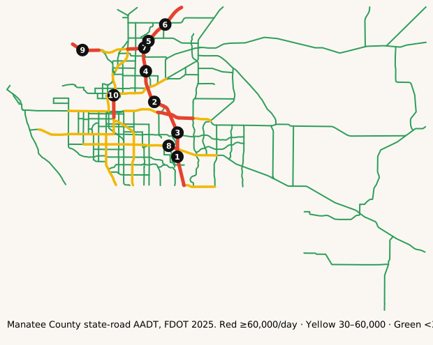
The busiest roads
Ranked by average daily vehicles. Bring snacks for anything near the top.
| Corridor | Avg AADT | Peak segment | Miles | K |
|---|---|---|---|---|
| I-75 | 124,481 | 154,000 | 20.6 | 9.1% |
| I-275 | 45,833 | 66,500 | 5.2 | 9.0% |
| 9TH ST W | 42,220 | 45,000 | 1.4 | 9.0% |
| SR-70 | 40,983 | 74,500 | 15.6 | 9.0% |
| TAMIAMI TRAIL | 39,237 | 74,000 | 20.8 | 9.1% |
| US 301 | 38,093 | 44,000 | 7.9 | 9.0% |
| UNIVERSITY PKWY | 37,150 | 51,000 | 3.0 | 9.0% |
| 8TH AVE W | 35,491 | 45,500 | 8.6 | 9.0% |
Formula: Avg AADT = Σ(segment AADT × segment miles) ÷ Σ(segment miles), using FDOT's 2025 AADT segments in Manatee County.
Busiest single segments, 2025:
| Road | From → To | AADT |
|---|---|---|
| I-75 | SARASOTA CO LINE → Bridge No-130155 | 154,000 |
| I-75 | Bridge No-130084 → Bridge No-130103 | 142,500 |
| I-75 | Bridge No-130155 → Bridge No-130084 | 141,000 |
| I-75 | Bridge No-130103 → 13175310 SB ON | 115,000 |
| I-75 | 13175302 SB OFF → N/A | 105,500 |
| I-75 | N/A → HILLSBOROUGH CO LINE | 90,000 |
| I-75 | 13175310 SB ON → 13175302 SB OFF | 80,000 |
| SR-70 | FAIRWAY GARDENS DR → N/A | 74,500 |
| TAMIAMI TRAIL | 13175000 → BR #150189/150189 | 74,000 |
| TAMIAMI TRAIL | SR 64/MANATEE AVE → Bridge No-130002 | 68,000 |
| I-275 | RP 13175301 → Bridge No-130119 | 66,500 |
| TAMIAMI TRAIL | N/A → SR 64/6TH AVE | 65,500 |
AADT is the annual average number of vehicles per day on a segment. High volume isn't the same as congestion: freeways often carry the most because they have the most lanes.
How we know
- FDOT Annual Average Daily Traffic (Roadway Characteristics Inventory; public, "as is").
- Live list: FDOT DIVAS traffic events, Manatee County road closures. Pulled server-side every 5 minutes. Public FDOT GIS service, no key. FDOT provides data "as is". Public Manatee County ArcGIS FeatureServer (RoadClosures_public), no key. County GIS as-is / general reference disclaimer. Used for the Bradenton page and Tampa Bay master.
- Cameras: FL511 camera list (FDOT). Stills hot-linked from fl511.com; not stored here.
FAQ
What area does this cover?
Manatee County, Florida (Bradenton). Live incidents come from FDOT's DIVAS event feed filtered to that county.
How often does the live list update?
Every 5 minutes. The page is rebuilt from official feeds server-side; we don't invent counts.
Where do the traffic numbers come from?
FDOT Roadway Characteristics Inventory annual average daily traffic (AADT) for state roads in Manatee County, plus FL511 cameras. FDOT provides the data "as is".
Is this for navigation or emergencies?
No. For live routing use FL511 or your maps app. In an emergency call 911.
Last updated: AADT fetched October 27, 2026; page rebuilt October 27, 2026.