A Bad Time On The Roads · Lee County
Southwest Florida master map — Charlotte, Lee & Collier combined.
Is now a bad time to drive in Fort Myers?
Saved only in your browser.
Lee County looks calmer in the live feed. Weekly FDOT seasonal factors for Lee County aren't on this page yet. The badge follows today's live FDOT incidents (refreshed every 5 minutes). AADT map below is from FDOT 2025 counts.
Live right now
0 incidents · 0 full road closures · 0 signal issues in Lee County.
No geocoded incidents or full closures right now. Closures without coordinates stay in the list.
Nothing reported by official sources right now.
Sources, rule and fine print
- FDOT DIVAS traffic events (Florida Department of Transportation): ok, 0 in Lee County. Public FDOT GIS service, no key. FDOT provides data "as is".
Live label (our rule): Only incidents, full road closures, and signal issues set the badge. Math: Bad = any signal, any full road closure, or a crash / major or intermediate-severity incident; Meh = any other incident; Good = none of those. Permitted lane/utility work and other non-full scheduled work are listed separately and do not change Bad/Meh/Good. Counts are what the agencies list; we don't invent any.
Signal outages: appear here only when FDOT posts them to its event feed.
📷 Nearby cameras: FL511 (FDOT) cameras within 1.5 km of the reported location, straight-line. Stills are hot-linked from fl511.com (not stored or proxied here) and refresh in your browser while this page is open.
Times are Eastern. Incident text is pulled server-side. The optional map loads Leaflet from abadtime.com and map tiles from tile.openstreetmap.org (OSM tile policy; low volume, attribution shown). Camera links open fl511.com. Not for navigation or emergencies.
County road & lane closures
Open official county closure map →
No public keyless Lee County closure FeatureServer with acceptable terms was verified this pass. We show FDOT DIVAS events for Lee County and link FL511 for the official live map. Lee County / FL511.
Official live maps:
- FL511 live traffic map (FDOT): Official statewide live incidents, closures, travel times and cameras.
- Florida Traffic Online (FDOT): FDOT traffic counts, site reports and seasonal factors.
Traffic cameras (61)
Each link opens that camera on the official FL511 map (FDOT) via #camera-{id}. We don't host, copy or re-stream any images or video. Lee County; list checked daily, last on Oct 27.
I-75 (60)
- 1565S 75 S/O Tuckers Grd M156 Southbound
- 1560N 75 S/O Tuckers Grd M156 Northbound
- 1550N 75 S/O Tuckers Grd M155 Northbound
- 1550S 75 S/O Tuckers Grd M155 Southbound
- 1540N 75 S/O Tuckers Grd M154 Northbound
- 1529S 75 S/O Tuckers Grd M152 Northbound
- 1519N 75 S/O Tuckers Grd M151 Northbound
- 1519S 75 S/O Tuckers Grd M151 Southbound
- 1510N 75 S/O Tuckers Grd M151 Northbound
- 1510S 75 S/O Tuckers Grd M151 Southbound
- 1501N 75 N/O Bayshore Rd M150 Northbound
- 1501S 75 N/O Bayshore Rd M150 Southbound
- 1491N 75 N/O Bayshore M149 Northbound
- 1484S 75 S/O TuckerGrade M148 Southbound
- 1458S 75 S/O TuckerGrade M146 Southbound
- 1447N 75 N/O Bayshore M145 Northbound
- 1432N 75 At Bayshore M143 Northbound
- 1430S 75 At Bayshore M143 Southbound
- 1425N 75 N/O PalmBeach M143 Northbound
- 1412N 75 At PalmBeach M141 Northbound
- 1403N 75 N/O Luckett M140 Northbound
- 1393N 75 At Luckett M139 Northbound
- 1393S 75 At Luckett M139 Southbound
- 1393M 75 At Luckett M139 Southbound
- 1385N 75 N/O MLKJr M138 Northbound
- 1377N 75 At MLKJr M138 Northbound
- 1370S 75 SO MLKJr M137 Southbound
- 1366N 75 SO Colonial M136 Northbound
- 1361N 75 At Colonial M136 Northbound
- 1349N 75 N/O Daniels M135 Northbound
- 1340S 75 S/O Colonial M134 Southbound
- 1340N 75 N/O Colonial M134 Northbound
- 1325S 75 S/O Colonial M133 Southbound
- 1325N 75 N/O Daniels M133 Northbound
- 1315M 75 S/O DANIELS M131 B Southbound
- 1315S 75 S/O DANIELS M131 Southbound
- 1315N 75 S/O DANIELS M131 Northbound
- 1315M 75 S/O DANIELS M131 A Northbound
- 1305N 75 S/O DANIELS PKWY M130 Northbound
- 1302N 75 S/O DANIELS PKWY M130 Northbound
- 1298N COHU Northbound
- 1290N 75 S/O TERMINAL ACCESS RD M129 Northbound
- 1286N 75 S/O TERMINAL ACCESS RD M129 Northbound
- 1278N 75 At Alico M128 Northbound
- 1267S 75 S/O Alico M127 Southbound
- 1260N 75 N/O Alico M126 Southbound
- 1252S 75 S/O Alico M125 Southbound
- 1246N 75 N/O Corkscrew M125 Northbound
- 1235S 75 At Corkscrew M124 Southbound
- 1226N 75 N/O BonitaBeach M123 Northbound
- 1205S 75 S/O Corkscrew M121 Southbound
- 1195S 75 S/O Corkscrew M120 Southbound
- 1185S 75 N/O BonitaBeach Northbound
- 1176N 75 N/O BonitaBeach M118 Northbound
- 1160S Bonita Beach M116 Southbound
- 1160N Bonita Beach M116 Northbound
- 1159N Bonita Beach M116 Northbound
- 1159S Bonita Beach M116 Southbound
- 1153S 75 S/O BonitaBeach M115 Southbound
- 1142N 75 N/O Immokalee M114 Northbound
US 41 (1)
- 1361S 75 At Colonial Southbound
Source: FL511 camera list, Florida Department of Transportation. FL511 says video and images are neither stored nor recorded; FDOT information is not for re-sale or re-use, so we only link.
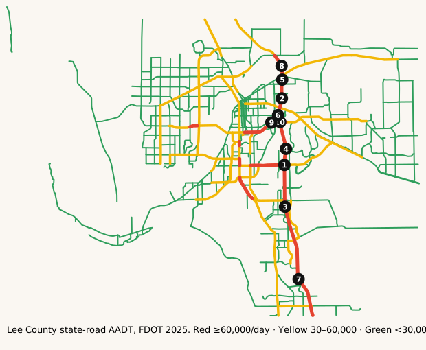
Map: where it's busy
FDOT annual average daily traffic on state roads in Lee County.
Legend: ■ 60,000+ vehicles/day · ■ 30,000–60,000 · ■ under 30,000 (our bins). Static map · Report a map issue
The busiest roads
Ranked by average daily vehicles. Bring snacks for anything near the top.
| Corridor | Avg AADT | Peak segment | Miles | K |
|---|---|---|---|---|
| I-75 | 102,955 | 129,200 | 34.1 | 9.1% |
| ALICO RD | 50,000 | 50,000 | 2.7 | 9.0% |
| DANIELS PKWY | 49,091 | 67,000 | 13.3 | 9.0% |
| US-41 | 47,958 | 71,000 | 33.4 | 9.0% |
| VETERANS PKWY | 44,626 | 68,500 | 11.3 | 9.0% |
| CAPE CORAL PKWY | 40,633 | 53,000 | 6.3 | 9.0% |
| COLONIAL BLVD | 40,350 | 74,500 | 26.3 | 9.0% |
| COLLEGE PKWY | 38,459 | 39,000 | 1.7 | 9.0% |
Formula: Avg AADT = Σ(segment AADT × segment miles) ÷ Σ(segment miles), using FDOT's 2025 AADT segments in Lee County.
Busiest single segments, 2025:
| Road | From → To | AADT |
|---|---|---|
| I-75 | Bridge No-120187 → Bridge No-120106 | 129,200 |
| I-75 | Bridge No-120122 → Bridge No-120090 | 120,000 |
| I-75 | 12075008 SB OFF → Bridge No-120187 | 116,500 |
| I-75 | Bridge No-120106 → Bridge No-120120 | 114,500 |
| I-75 | Bridge No-120090 → Bridge No-120093 | 112,000 |
| I-75 | Bridge No-120120 → Bridge No-120122 | 109,000 |
| I-75 | COLLIER CO LINE → 12075008 SB OFF | 106,000 |
| I-75 | Bridge No-120093 → Bridge No-120112 | 90,000 |
| COLONIAL BLVD | WINKLER AVE → 6M CYPRES PKWY/CR865 | 74,500 |
| COLONIAL BLVD | 6M CYPRES PKWY/CR865 → STATE R/W LINE | 74,000 |
| COLONIAL BLVD | FOWLER ST → METRO PKWY/SR 739 | 72,500 |
| US-41 | DANIELS PKWY → WOODLAND BLVD | 71,000 |
AADT is the annual average number of vehicles per day on a segment. High volume isn't the same as congestion: freeways often carry the most because they have the most lanes.
How we know
- FDOT Annual Average Daily Traffic (Roadway Characteristics Inventory; public, "as is").
- Live list: FDOT DIVAS traffic events. Pulled server-side every 5 minutes. Public FDOT GIS service, no key. FDOT provides data "as is".
- Cameras: FL511 camera list (FDOT). Stills hot-linked from fl511.com; not stored here.
FAQ
What area does this cover?
Lee County, Florida (Fort Myers / Cape Coral). Live incidents come from FDOT's DIVAS event feed filtered to that county.
How often does the live list update?
Every 5 minutes. The page is rebuilt from official feeds server-side; we don't invent counts.
Where do the traffic numbers come from?
FDOT Roadway Characteristics Inventory annual average daily traffic (AADT) for state roads in Lee County, plus FL511 cameras. FDOT provides the data "as is".
Is this for navigation or emergencies?
No. For live routing use FL511 or your maps app. In an emergency call 911.
Last updated: AADT fetched October 27, 2026; page rebuilt October 28, 2026.