A Bad Time On The Roads · Collier County
Southwest Florida master map — Charlotte, Lee & Collier combined.
Is now a bad time to drive in Naples?
Saved only in your browser.
Collier County looks calmer in the live feed. Weekly FDOT seasonal factors for Collier County aren't on this page yet. The badge follows today's live FDOT incidents (refreshed every 5 minutes). AADT map below is from FDOT 2025 counts.
Live right now
0 incidents · 0 full road closures · 0 signal issues · 2 scheduled road work in Collier County.
2 pins for incidents / full closures / signals (verdict drivers). Red = Bad · Amber = Meh. Closures without coordinates stay in the list.
Scheduled road work (2)
Listed for awareness; does not change the live label (only full road closures and incidents do).
- Scheduled Road Work I-75 @ Collier Blvd Off-ramp right lanes blocked
Planned construction in Collier County on I-75 South, ramp to Exit 101: Collier Blvd. (CR-951). Off-ramp right lanes blocked.
Florida Department of Transportation · updated 10/28/2026 12:12:58 AM ET
📷 Nearby cameras: 1024S 75 S/O GoldenGate M102 (860 m) · 1024N 75 N/O Collier M102 (875 m) - Scheduled Road Work I-75 @ Collier Blvd Off-ramp center lane blocked
Planned construction in Collier County on I-75 North, ramp to Exit 101: Collier Blvd. (CR-951). Off-ramp center lane blocked.
Florida Department of Transportation · updated 10/27/2026 10:08:31 PM ET
📷 Nearby camera: 1003N 75 Alligator Alley M100 (1.2 km)
Sources, rule and fine print
- FDOT DIVAS traffic events (Florida Department of Transportation): ok, 2 in Collier County. Public FDOT GIS service, no key. FDOT provides data "as is".
Live label (our rule): Only incidents, full road closures, and signal issues set the badge. Math: Bad = any signal, any full road closure, or a crash / major or intermediate-severity incident; Meh = any other incident; Good = none of those. Permitted lane/utility work and other non-full scheduled work are listed separately and do not change Bad/Meh/Good. Counts are what the agencies list; we don't invent any.
Signal outages: appear here only when FDOT posts them to its event feed.
📷 Nearby cameras: FL511 (FDOT) cameras within 1.5 km of the reported location, straight-line. Stills are hot-linked from fl511.com (not stored or proxied here) and refresh in your browser while this page is open.
Times are Eastern. Incident text is pulled server-side. The optional map loads Leaflet from abadtime.com and map tiles from tile.openstreetmap.org (OSM tile policy; low volume, attribution shown). Camera links open fl511.com. Not for navigation or emergencies.
County road & lane closures
Open official county closure map →
No public keyless Collier County closure FeatureServer with acceptable terms was verified this pass. We show FDOT DIVAS events for Collier County and link FL511 for the official live map. Collier County / FL511.
Official live maps:
- FL511 live traffic map (FDOT): Official statewide live incidents, closures, travel times and cameras.
- Florida Traffic Online (FDOT): FDOT traffic counts, site reports and seasonal factors.
Traffic cameras (66)
Each link opens that camera on the official FL511 map (FDOT) via #camera-{id}. We don't host, copy or re-stream any images or video. Collier County; list checked daily, last on Oct 27.
I-75 (65)
- 1246N 75 N/O Corkscrew M125 Northbound
- 1235S 75 At Corkscrew M124 Southbound
- 1226N 75 N/O BonitaBeach M123 Northbound
- 1205S 75 S/O Corkscrew M121 Southbound
- 1195S 75 S/O Corkscrew M120 Southbound
- 1185S 75 N/O BonitaBeach Northbound
- 1176N 75 N/O BonitaBeach M118 Northbound
- 1160S Bonita Beach M116 Southbound
- 1160N Bonita Beach M116 Northbound
- 1159N Bonita Beach M116 Northbound
- 1159S Bonita Beach M116 Southbound
- 1153S 75 S/O BonitaBeach M115 Southbound
- 1142N 75 N/O Immokalee M114 Northbound
- 1131N 75 At Imokalee M113 Northbound
- 1118N 75 At Immokalee M112 Northbound
- 1117S 75 At Immokalee M111 Southbound
- 1114S 75 S/O Immokalee M112 Northbound
- 12110N 75 N/O PineRidge M111 Northbound
- 1100N 75 N/O PineRidge M110 Northbound
- 1077M 75 At PineRidge M108 Southbound
- 1077M 75 At PineRidge M108 Northbound
- 1077N 75 At PineRidge M108 Northbound
- 1068N 75 N/O GoldenGate M107 Northbound
- 1052S 75 At GoldenGate M105 Southbound
- 0517N 75 Alligator Alley M052 Northbound
- 0536N 75 Alligator Alley M054 Northbound
- 0576N 75 Alligator Alley M058 Northbound
- 0595N 75 Alligator Alley M060 Northbound
- 0611N 75 Alligator Alley M061 Northbound
- 0555S 75 Alligator Alley M056 Southbound
- 0633N 75 TPASS Coll Co-C Northbound
- 0610S 75 Alligator Alley M061 Southbound
- 0650N 75 Alligator Alley M065 Northbound
- 0687N 75 Alligator Alley M069 Northbound
- 0631S 75 Alligator Alley M063 Southbound
- 0707N 75 Alligator Alley M071 Northbound
- 0631S 75 Alligator Alley M063 Southbound
- 1045N 75 N/O Collier M104 Northbound
- 0724N 75 Alligator Alley M072 Northbound
- 0660S 75 Alligator Alley M066 Southbound
- 0668S 75 Alligator Alley M067 Southbound
- 1046S 75 S/O GoldenGate M105 Southbound
- 0734N 75 Alligator Alley -AIS2 Northbound
- 1024N 75 N/O Collier M102 Northbound
- 1034N 75 N/O Collier M103 Northbound
- 1024S 75 S/O GoldenGate M102 Southbound
- 1034S 75 S/O GoldenGate M103 Southbound
- 0744N 75 Alligator Alley M074 Northbound
- 0763N 75 Alligator Alley M076 Northbound
- 1003N 75 Alligator Alley M100 Northbound
- 0782N 75 Alligator Alley M078 Northbound
- 0800N 75 At SR29 M080 Northbound
- 0995N 75 Alligator Alley M099 Northbound
- 0821N 75 Alligator Alley M082 Northbound
- 0976N 75 Alligator Alley M098 Northbound
- 0800N 75 At SR29 M080-A Northbound
- 0840N 75 Alligator Alley M084 Northbound
- 0986N 75 Alligator Alley M098 Northbound
- 0957N 75 Alligator Alley M096 Northbound
- 0859N 75 Alligator Alley M086 Northbound
- 0878N 75 Alligator Alley M088 Northbound
- 0898N 75 Alligator Alley M090 Northbound
- 0918N 75 Alligator Alley M092 Northbound
- 0926N 75 Alligator Alley HUB Northbound
- 0938N 75 Alligator Alley M094 Northbound
US 41 (1)
- MCO US41 SR29 Northbound
Source: FL511 camera list, Florida Department of Transportation. FL511 says video and images are neither stored nor recorded; FDOT information is not for re-sale or re-use, so we only link.
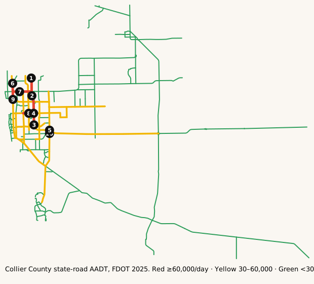
Map: where it's busy
FDOT annual average daily traffic on state roads in Collier County.
Legend: ■ 60,000+ vehicles/day · ■ 30,000–60,000 · ■ under 30,000 (our bins). Static map · Report a map issue
The busiest roads
Ranked by average daily vehicles. Bring snacks for anything near the top.
| Corridor | Avg AADT | Peak segment | Miles | K |
|---|---|---|---|---|
| COLLIER BLVD. | 66,500 | 66,500 | 0.6 | 9.0% |
| PINE RIDGE RD | 53,619 | 72,000 | 5.0 | 9.0% |
| CR 886/GOLDEN GATE | 51,665 | 59,500 | 4.2 | 9.0% |
| AIRPORT PULLING RD | 45,995 | 54,000 | 7.8 | 9.0% |
| GOLDEN GATE PKWY | 43,311 | 59,500 | 5.8 | 9.0% |
| ALLIGATOR ALY | 40,178 | 116,388 | 63.6 | 9.5% |
| SANTA BARBARA BLVD | 39,916 | 52,500 | 4.2 | 9.0% |
| 23 RD ST SW | 38,500 | 38,500 | 6.3 | 9.0% |
Formula: Avg AADT = Σ(segment AADT × segment miles) ÷ Σ(segment miles), using FDOT's 2025 AADT segments in Collier County.
Busiest single segments, 2025:
| Road | From → To | AADT |
|---|---|---|
| ALLIGATOR ALY | Bridge No-030321 → LEE COUNTY LINE | 116,388 |
| ALLIGATOR ALY | Bridge No-030200 → Bridge No-030321 | 92,396 |
| ALLIGATOR ALY | GOLDEN GT PKWY/CR886 → Bridge No-030200 | 85,500 |
| PINE RIDGE RD | LIVINGSTON RD → N/A | 72,000 |
| COLLIER BLVD. | BECK BLVD → ENDS @ RIGHT OF WAY | 66,500 |
| TAMIAMI TRL | SHOPPING CENTER ENT → 111TH AVE N/CR 846 | 62,000 |
| IMMOCKALEE RD/CR 846 | SR 45/US 41 → TURNOUT TO I75 SB | 61,000 |
| PINE RIDGE RD | AIRPORT PULLING/CR31 → LIVINGSTON RD | 60,500 |
| TAMIAMI TRL | 111TH AVE N/CR 846 → VANDER BCH RD/CR 862 | 60,000 |
| N COLLIER BLVD | N/A → BECK BLVD | 60,000 |
| GOLDEN GATE PKWY | BEARS PAW TR → N/A | 59,500 |
| CR 886/GOLDEN GATE | Bridge No-030199 → N/A | 59,500 |
AADT is the annual average number of vehicles per day on a segment. High volume isn't the same as congestion: freeways often carry the most because they have the most lanes.
How we know
- FDOT Annual Average Daily Traffic (Roadway Characteristics Inventory; public, "as is").
- Live list: FDOT DIVAS traffic events. Pulled server-side every 5 minutes. Public FDOT GIS service, no key. FDOT provides data "as is".
- Cameras: FL511 camera list (FDOT). Stills hot-linked from fl511.com; not stored here.
FAQ
What area does this cover?
Collier County, Florida (Naples). Live incidents come from FDOT's DIVAS event feed filtered to that county.
How often does the live list update?
Every 5 minutes. The page is rebuilt from official feeds server-side; we don't invent counts.
Where do the traffic numbers come from?
FDOT Roadway Characteristics Inventory annual average daily traffic (AADT) for state roads in Collier County, plus FL511 cameras. FDOT provides the data "as is".
Is this for navigation or emergencies?
No. For live routing use FL511 or your maps app. In an emergency call 911.
Last updated: AADT fetched October 27, 2026; page rebuilt October 28, 2026.