A Bad Time On The Roads · Charlotte County
Southwest Florida master map — Charlotte, Lee & Collier combined.
Is now a bad time to drive in Port Charlotte?
Saved only in your browser.
Charlotte County looks calmer in the live feed. Weekly FDOT seasonal factors for Charlotte County aren't on this page yet. The badge follows today's live FDOT incidents (refreshed every 5 minutes). AADT map below is from FDOT 2025 counts.
Live right now
0 incidents · 0 full road closures · 0 signal issues · 1 scheduled road work in Charlotte County.
1 pin for incidents / full closures / signals (verdict drivers). Red = Bad · Amber = Meh. Closures without coordinates stay in the list.
Scheduled road work (1)
Listed for awareness; does not change the live label (only full road closures and incidents do).
- Scheduled Road Work I-75 @ Mile Marker 165 2 Right lanes blocked
Planned construction in Charlotte County on I-75 North, before Mile Marker 165. 2 Right lanes blocked.
Florida Department of Transportation · updated 10/28/2026 12:23:16 AM ET
📷 Nearby cameras: 1650N 75 N/O US17 M165 (130 m) · 1644N 75 at US17 M164B (1.0 km)
Sources, rule and fine print
- FDOT DIVAS traffic events (Florida Department of Transportation): ok, 1 in Charlotte County. Public FDOT GIS service, no key. FDOT provides data "as is".
Live label (our rule): Only incidents, full road closures, and signal issues set the badge. Math: Bad = any signal, any full road closure, or a crash / major or intermediate-severity incident; Meh = any other incident; Good = none of those. Permitted lane/utility work and other non-full scheduled work are listed separately and do not change Bad/Meh/Good. Counts are what the agencies list; we don't invent any.
Signal outages: appear here only when FDOT posts them to its event feed.
📷 Nearby cameras: FL511 (FDOT) cameras within 1.5 km of the reported location, straight-line. Stills are hot-linked from fl511.com (not stored or proxied here) and refresh in your browser while this page is open.
Times are Eastern. Incident text is pulled server-side. The optional map loads Leaflet from abadtime.com and map tiles from tile.openstreetmap.org (OSM tile policy; low volume, attribution shown). Camera links open fl511.com. Not for navigation or emergencies.
County road & lane closures
Open official county closure map →
No public keyless live closure FeatureServer found for Charlotte County. Traffic advisories are posted as county news; we link the Public Works page and show FDOT events for the county. Charlotte County Public Works.
Official live maps:
- FL511 live traffic map (FDOT): Official statewide live incidents, closures, travel times and cameras.
- Charlotte County Public Works: County roads, traffic advisories and contacts.
- Florida Traffic Online (FDOT): FDOT traffic counts, site reports and seasonal factors.
Traffic cameras (131)
Each link opens that camera on the official FL511 map (FDOT) via #camera-{id}. We don't host, copy or re-stream any images or video. Charlotte County; list checked daily, last on Oct 27.
I-75 (78)
- 1970N 75 N/O LAUREL RD M197 Northbound
- 1960N 75 S/O LAUREL RD M196 Northbound
- 1962S 75 N/O LAUREL RD M196 Southbound
- 1953S 75 S/O LAUREL RD M195 Southbound
- 1947N 75 S/O BORDER DR M195 Northbound
- 1938S 75 N/O JACARANDA BLVD M194 Southbound
- 1895N 75 S/O SOUTH MOON DR M189 Northbound
- 1905N 75 S/O SOUTH MOON DR M190 Northbound
- 1898S 75 S/O SOUTH MOON DR M190 Southbound
- 1934S 75 N/O JACARANDA BLVD M193 Southbound
- 1916N 75 N/O RIVER RD M192 Northbound
- 1891N 75 S/O SOUTH MOON DR M189 Northbound
- 1922N 75 N/O JACKSON RD M192 Northbound
- 1932S 75 S/O JACARANDA BLVD MI93 Southbound
- 1892S 75 S/O SOUTH MOON DR M189 Southbound
- 1885N S/O SOUTH MOON M188 Northbound
- 1876S 75 S/O SOUTH MOON DR M188 Southbound
- 1873N 75 N/O PONCE DE LEON BLVD M187 Northbound
- 1868N 75 N/O PONCE DE LEON BLVD M187 Northbound
- 1853N 75 N/O PONCE DE LEON BLVD M185 Northbound
- 1871S 75 N/O PONCE DE LEON BLVD M187 Southbound
- 1833N 75 S/O PONCE DE LEON BLVD M183 Northbound
- 1824N 75 S/O SUMTER BLVD M182 Southbound
- 1865S 75 N/O PONCE DE LEON BLVD M186 Southbound
- 1811N 75 S/O SUMTER BLVD M181 Northbound
- 1815N 75 S/O SUMTER BLVD M181 Northbound
- 1805N 75 N/O Toledo Blade Blvd M180 Northbound
- 1844S 75 N/O PONCE DE LEON BLVD M184 Southbound
- 1795N 75 N/O Toledo Blade Blvd M179 Northbound
- 1779N 75 S/O Toledo Blade M178 Northbound
- 1824N 75 S/O SUMTER BLVD M183 Northbound
- 1780S 75 S/O Toledo Blade Blvd M178 Southbound
- 1778S 75 S/O Toledo Blade Blvd M178 Southbound
- 1773S 75 S/O Toledo Blade Blvd M177 Southbound
- 1773N 75 S/O Toledo Blade Blvd M177 Northbound
- 1762N 75 N/O Yorkshire ST M176 Northbound
- 1752N 75 N/O Yorkshire ST M175 Northbound
- 1742N 75 N/O Yorkshire ST M174 Northbound
- 1732N 75 S/O Yorkshire ST M173 Northbound
- 1722S 75 N/O Kings Hwy M172 Southbound
- 1703N 75 At Kings Hwy M170 Northbound
- 1694N 75 S/O Kings Hwy M169 Northbound
- 1684N 75 N/O Harborview M168 Northbound
- 1684S 75 N/O Harborview M168 Southbound
- 1672N 75 At Harborview M167 Northbound
- 1666N 75 S/O Harborview M166 Northbound
- 1650N 75 N/O US17 M165 Northbound
- 1644N 75 at US17 M164B Northbound
- 1644N 75 at US17 M164 Northbound
- 1630N 75 S/O US17 M163 Northbound
- 1619N 75 N/O Jones Loop M162 Northbound
- 1597N 75 S/O Jones Loop M159 Northbound
- 1595N 75 TPASS Char Co Northbound
- 1595S 75 TPASS Char Co Southbound
- 1595N 75 TPASS Char Co-A Northbound
- 1594S 75 TPASS Char Co-A Southbound
- 1587N 75 N/O Tuckers Grd M158 Northbound
- 1580N 75 N/O Tuckers Grd M158 Northbound
- 1578S 75 At Tuckers Grd M157 Southbound
- 1565S 75 S/O Tuckers Grd M156 Southbound
- 1560N 75 S/O Tuckers Grd M156 Northbound
- 1550N 75 S/O Tuckers Grd M155 Northbound
- 1550S 75 S/O Tuckers Grd M155 Southbound
- 1540N 75 S/O Tuckers Grd M154 Northbound
- 1529S 75 S/O Tuckers Grd M152 Northbound
- 1519N 75 S/O Tuckers Grd M151 Northbound
- 1519S 75 S/O Tuckers Grd M151 Southbound
- 1510N 75 S/O Tuckers Grd M151 Northbound
- 1510S 75 S/O Tuckers Grd M151 Southbound
- 1501N 75 N/O Bayshore Rd M150 Northbound
- 1501S 75 N/O Bayshore Rd M150 Southbound
- 1491N 75 N/O Bayshore M149 Northbound
- 1484S 75 S/O TuckerGrade M148 Southbound
- 1458S 75 S/O TuckerGrade M146 Southbound
- 1447N 75 N/O Bayshore M145 Northbound
- 1432N 75 At Bayshore M143 Northbound
- 1430S 75 At Bayshore M143 Southbound
- 1425N 75 N/O PalmBeach M143 Northbound
US 41 (34)
- SA US41 @ Roberts Rd/Spanish Lake Blvd 1056/884 Northbound
- SA US41 @ Laurel Rd 1054/883 Southbound
- SA US41 @ Albee Rd 1052/882 Southbound
- SA US41 @ Colonia Lane 1048/880 Southbound
- SA US41 @ US41BUS N Northbound
- SA US41 @ Bird Bay Dr 1044/990 Northbound
- SA US41 @ Albee Farm Rd 1040/988 Southbound
- SA US41 @ Venice Ave 860/ Southbound
- SA US41B @ Venice Ave E & W 1038/876 Northbound
- SA US41B @ San Marco Dr 6002/871 Northbound
- SA US41B @ Avenida Del Circo 1036/870 Southbound
- SA Midblock US41 @ STA 141 70 Northbound
- SA US41B @ Center Rd 869/1035 Northbound
- SA US41 @ Shamrock Blvd 1032/867 Southbound
- SA US41 @ Lowes/Venetian Plaza Ent 1030/866 Southbound
- SA US41 @ Seminole Dr 1028/865 Northbound
- SA US41 @ Alligator Dr/Galleria Plaza 1026/864 Southbound
- SA US41 @ Woodmere Park Blvd 1020/861 Northbound
- SA US41 @ Venice East Blvd Southbound
- SA US41 @ Jacaranda Blvd 1022/862 Southbound
- SA US41 @ Preto Blvd Northbound
- SA US41 @ Rockley Blvd/Taylor Ranch Trl 1018/859 Northbound
- SA US41 @ West Villiages Pkwy 7014/1046 Southbound
- SA US41 @ Galleria Blvd/Corradino Blvd 7016/1531 Northbound
- SA US41 @ Ortiz Blvd/Talon Bay Dr 1016/857 Northbound
- SA US41 @ Biscayne Dr 7012/856 Northbound
- SA US41 @ S Pan American Blvd 7010/855 Northbound
- SA US41 @ North Port Blvd 7008/854 Northbound
- SA US41 @ CR777/River Rd Northbound
- SA US41 @ River Rd CAM 2 Northbound
- SA US41 @ Tuscola Blvd 1050/7006 Northbound
- SA US41 @ Sumter Blvd 7004/853 Northbound
- SA US41 @ Home Depot Ent Northbound
- SA US41 @ Salford Boulevard 7000/851 Northbound
SR 776 (7)
- SA US41 @ SR776/Englewood Dr Northbound
- SA N Indiana Ave (SR776) @ Jacaranda Blvd 1015/952 Northbound
- SA N Indiana Ave (SR776) @ Rutgers Rd/Flea Market 1013/951 Northbound
- SA N Indiana Ave (SR776) @ Manasota Beach Rd 1011/950 Northbound
- SA N Indiana Ave (SR776) @ Overbrook Rd Northbound
- SA N Indiana Ave (SR776) @ Dearborn St Northbound
- SA N Indiana Ave (SR776) @ Virginia Court 1001/945 Northbound
Jacaranda Blvd (3)
- SA Jacaranda Blvd @ Executive Northbound
- SA Jacaranda Blvd @ Center Rd Southbound
- SA Jacaranda Blvd @ Woodmere Park Blvd Southbound
SR 777 / S River Rd (3)
- SA SR777 @ Venice Ave Northbound
- SA SR777 @ Center Rd Northbound
- SA SR777 @ West Villages Northbound
US 41 Business (2)
- SA US41B @ Tampa Ave W 6014/877 Northbound
- SA US41B @ Miami Ave W 6010/875 Northbound
Auburn Rd (1)
- SA Venice Ave @ Auburn Rd Northbound
Hwy 681 (1)
- SA Midblock US41 @ HWY 681 Eastbound
Laurel Rd (1)
- SA Laurel Rd @ Albee Farm Rd N Eastbound
Venice Ave (1)
- SA Venice Ave @ Pinebrook Rd Eastbound
Source: FL511 camera list, Florida Department of Transportation. FL511 says video and images are neither stored nor recorded; FDOT information is not for re-sale or re-use, so we only link.
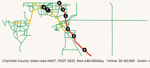
Map: where it's busy
FDOT annual average daily traffic on state roads in Charlotte County.
Legend: ■ 60,000+ vehicles/day · ■ 30,000–60,000 · ■ under 30,000 (our bins). Static map · Report a map issue
The busiest roads
Ranked by average daily vehicles. Bring snacks for anything near the top.
| Corridor | Avg AADT | Peak segment | Miles | K |
|---|---|---|---|---|
| I-75 | 72,206 | 81,500 | 22.0 | 9.4% |
| TAMIAMI TRL | 33,851 | 60,500 | 25.9 | 9.1% |
| S MCCALL RD/SR-776 | 32,616 | 37,000 | 15.3 | 9.0% |
| CROSS ST US 41 SB | 30,294 | 33,000 | 2.0 | 9.0% |
| VETERANS BLVD | 28,000 | 28,000 | 7.0 | 9.0% |
| COCHRAN BLVD | 21,500 | 21,500 | 0.1 | 9.0% |
| TOLEDO BLADE BLVD | 21,000 | 21,000 | 1.8 | 9.0% |
| KINGS HIGHWAY | 20,589 | 26,500 | 5.3 | 9.0% |
Formula: Avg AADT = Σ(segment AADT × segment miles) ÷ Σ(segment miles), using FDOT's 2025 AADT segments in Charlotte County.
Busiest single segments, 2025:
| Road | From → To | AADT |
|---|---|---|
| I-75 | Bridge No-010076 → Bridge No-010059 | 81,500 |
| I-75 | Bridge No-010073 → Bridge No-010076 | 76,916 |
| I-75 | Bridge No-010059 → Bridge No-010071 | 70,000 |
| I-75 | LEE COUNTY LINE → Bridge No-010082 | 70,000 |
| I-75 | Bridge No-010082 → Bridge No-010073 | 69,500 |
| I-75 | Bridge No-010071 → DESOTO CO LINE | 64,500 |
| TAMIAMI TRL | MIDWAY BLVD → COCHRAN BLVD | 60,500 |
| TAMIAMI TRL | COCHRAN BLVD → MURDOCK CIR | 55,000 |
| TAMIAMI TRL | HARBOR BLVD → MIDWAY BLVD | 55,000 |
| TAMIAMI TRL | MURDOCK CIR → VETERANS BLVD | 50,000 |
| TAMIAMI TRL | MELBOURNE ST → HARBOR BLVD | 45,500 |
| TAMIAMI TRL | VETERANS BLVD → TOLEDO BLADE BLVD | 42,000 |
AADT is the annual average number of vehicles per day on a segment. High volume isn't the same as congestion: freeways often carry the most because they have the most lanes.
How we know
- FDOT Annual Average Daily Traffic (Roadway Characteristics Inventory; public, "as is").
- Live list: FDOT DIVAS traffic events. Pulled server-side every 5 minutes. Public FDOT GIS service, no key. FDOT provides data "as is".
- Cameras: FL511 camera list (FDOT). Stills hot-linked from fl511.com; not stored here.
FAQ
What area does this cover?
Charlotte County, Florida (Port Charlotte / Punta Gorda). Live incidents come from FDOT's DIVAS event feed filtered to that county.
How often does the live list update?
Every 5 minutes. The page is rebuilt from official feeds server-side; we don't invent counts.
Where do the traffic numbers come from?
FDOT Roadway Characteristics Inventory annual average daily traffic (AADT) for state roads in Charlotte County, plus FL511 cameras. FDOT provides the data "as is".
Is this for navigation or emergencies?
No. For live routing use FL511 or your maps app. In an emergency call 911.
Last updated: AADT fetched October 27, 2026; page rebuilt October 28, 2026.