A Bad Time On The Roads · Hillsborough County
Tampa Bay Area master map — Hillsborough, Pinellas & Manatee combined.
Is now a bad time to drive in Tampa?
Saved only in your browser.
Live feed shows official trouble in Hillsborough County. Weekly FDOT seasonal factors for Hillsborough County aren't on this page yet. The badge follows today's live FDOT incidents (refreshed every 5 minutes). AADT map below is from FDOT 2025 counts.
Live right now
0 incidents · 19 full road closures · 0 signal issues · 7 scheduled road work · 552 permitted lane work in Hillsborough County.
26 pins for incidents / full closures / signals (verdict drivers). Red = Bad · Amber = Meh. 552 permitted lane-work points stay off until you toggle them. Closures without coordinates stay in the list.
By source: Florida Department of Transportation (7) · Hillsborough County (571)
Full road closures (19)
- 24 Hour Road Closure Victoria St · Limona Rd to N. Parsons Ave Other
This permit request is to perform the open cut pipeline construction along Victoria St. for the TBW South Hillsborough Pipeline Project. The open cut construction would be executed from Limona Rd. along Victoria St. to N. Moon Rd. Scope of work will include, saw cut and removal of pavement, utility locates, excavation of the trench, installation of OSHA-approved shoring, installation of 60-inch steel water main, welding, backfilling, restoration of the road as necessary.
Hillsborough County · Jun 1, 8:00 AM ET – Nov 21, 5:00 PM ET - Daytime Road Closure Nundy Ave · Vern St to US-41 Outside Lane
Ric-Man is installing PVC Vacuum Mains for the Gibsonton Septic to Sewer Conversion Program CIP#19780
Hillsborough County · Jun 29, 8:00 AM ET – Dec 18, 4:00 PM ET - 24 Hour Road Closure Nundy Ave · Vern St to US-41 Outside Lane
Ric-Man is installing PVC Vacuum Mains for the Gibsonton Septic to Sewer Conversion Program CIP#19780
Hillsborough County · Jun 29, 8:00 AM ET – Dec 18, 5:00 PM ET - 24 Hour Road Closure Ronele Dr. · S. Kings Ave. to John Moore Rd. Other
This permit request is to perform the open cut pipeline construction along Ronele Dr.. for the TBW South Hillsborough Pipeline Project. This lane closure request is for the open cut pipeline installation along Ronele Dr. from S. Kings Ave. to John Moore Rd.The open cut construction would be executed in the center of the traffic lanes of Ronele Dr. Scope of work will include, saw cut and removal of pavement, utility locates, excavation of the trench, installation of OSHA-approved shoring, installation of 60-inch steel water main, welding, backfilling, restoration of the road.
Hillsborough County · Aug 17, 8:00 AM ET – Dec 19, 5:00 PM ET - 24 Hour Road Closure Jerry Smith Rd · Blankenship Rd to Hawks Creek Trail Other
replacing cross drain, headwalls, road buildback, grading, sod, M/OL
Hillsborough County · Sep 28, 8:00 AM ET – Nov 3, 5:00 PM ET - 24 Hour Road Closure Woodland Estates Ave · 10th St Sw to 10th St Sw Other
Roadway and stormwater improvements associated with Hillsborough County CIP #69631199, including drainage/culvert improvements, utility adjustments, roadway reconstruction, milling and resurfacing, and signing and pavement marking. Work will require temporary road closure and implementation of the approved detour/temporary traffic control plan.
Hillsborough County · Sep 30, 8:00 AM ET – Nov 5, 5:00 PM ET - 24 Hour Road Closure N Moon Ave · Victoria St to SR 60 Other
Scope of work will include, saw cut and removal of pavement, utility locates, excavation of the trench, installation of OSHA-approved shoring, installation of 60-inch steel water main, welding, backfilling, restoration of the road.
Hillsborough County · Oct 5, 8:00 AM ET – Mar 26, 5:00 PM ET - 24 Hour Road Closure Charlie Griffin Rd · SR39 James L Redman Parkway to Park Spring Cir Other
REMOVING AND REPLACING INLETS, CURB, GUTTER, SIDEWALK, CONCRETE PAVEMENT, AND SIGNAL COMPONENTS
Hillsborough County · Oct 23, 9:00 PM ET – Nov 9, 6:00 AM ET - 24 Hour Road Closure W Paris St · N Lincoln Ave to N Glen Ave Other
Repair our broken sewer pipe that broke in the street.
Hillsborough County · Oct 1, 8:00 AM ET – Nov 14, 4:45 PM ET
📷 Nearby cameras: Hillsborough Ave at Himes Ave (897 m) · Dale Mabry at Hillsborough Ave (1.1 km) - 24 Hour Road Closure lake magdalene blvd · Dyer Rd to Chickwood Ct Outside Lane
CIP project for storm drain installation and roadway reconstruction
Hillsborough County · Oct 7, 8:00 AM ET – Nov 6, 5:00 PM ET - 24 Hour Road Closure 7th Street SW · 16th Ave SW to Timeless Moss Dr Other
Utility_Installation
Hillsborough County · Oct 26, 9:00 AM ET – Nov 25, 4:00 PM ET - 24 Hour Road Closure 140th Ave · Sandy Ct to N 12th St Shoulder
Depression over our sewer mainline in the street.(Restore road back.)
Hillsborough County · Oct 16, 8:00 AM ET – Oct 31, 5:00 PM ET
📷 Nearby camera: I-275 at Fletcher Ave (1000 m) - 24 Hour Road Closure Hacienda Dr · Ojai Ave to Torrrey Pines Ave Inside Lane
Deflecting 12" water main and replacing Storm water box
Hillsborough County · Oct 14, 9:00 AM ET – Oct 28, 4:00 PM ET - Emergency Road Closure Clay Pit Rd · Legendary Oaks St to Williams Rd Other
Emergency Road Closure, FRAC-OUT OCCURRED 10/15/2026 ON CLAY PIT JOB SITE. NEED TO ROAD CLOSURE, DETOUR EAST LAKEWOOD TO WILLIMAS
Hillsborough County · Oct 15, 5:00 PM ET – Oct 30, 5:00 PM ET
📷 Nearby cameras: I-75 at MM 259.8 NB (803 m) · SR-574 at MM 11.5 WB (803 m) - 24 Hour Road Closure W Kyra Dr · N Armenia Ave to DEAD END Other
Repair our sewer pipe that broke.
Hillsborough County · Oct 17, 8:00 AM ET – Oct 30, 5:00 PM ET - 24 Hour Road Closure West Course Dr · Cloverlawn Dr to Apple Ridge Ln Other
Excavation to gravity sewer main to repair broken sewer tap for 16227 W Course Dr.
Hillsborough County · Oct 20, 8:00 AM ET – Nov 3, 5:00 PM ET - Daytime Road Closure 21St Ave SW · 4th St SW to na Other
other
Hillsborough County · Oct 26, 8:00 AM ET – Nov 30, 5:00 PM ET - 24 Hour Road Closure 11th Ave NE · US 41 to 3rd St NE Other
Install new water line and new storm line.
Hillsborough County · Oct 23, 8:00 AM ET – Dec 1, 5:00 PM ET - Daytime Road Closure Riverview Drive · US HWY 41 to Crowell Drive Outside Lane
WR # 2588074 replace 2 transmission poles, transfer distribution underbuilt. replace 3 transmission poles and reframe 1 transmission pole.
Hillsborough County · Oct 26, 9:00 AM ET – Oct 30, 4:00 PM ET
Scheduled road work (7)
Listed for awareness; does not change the live label (only full road closures and incidents do).
- Scheduled Road Work I-75 @ I-4 2 Left lanes blocked
Planned construction in Hillsborough County on I-75 North, at I-4. 2 Left lanes blocked.
Florida Department of Transportation · updated 10/27/2026 10:08:09 PM ET
📷 Nearby cameras: I-75 at SR 574 / MLK Jr Blvd (61 m) · SR-574 at MM 10.8 (305 m) - Scheduled Road Work I-4 @ I-275 Off-ramp left lane blocked
Planned construction in Hillsborough County on I-4 West, ramp to I-275 SB. Off-ramp left lane blocked.
Florida Department of Transportation · updated 10/27/2026 10:21:15 PM ET
📷 Nearby cameras: I-275 SB at I-4 (82 m) · I-275 NB at I-4 Ramp (144 m) - Scheduled Road Work Veterans Expressway Thru Lanes @ Gunn Hwy All lanes closed
Planned construction in Hillsborough County on Veterans Expressway Thru Lanes North, at Exit 9: Gunn Hwy S.R. 587. All lanes closed.
Florida Department of Transportation · updated 10/27/2026 9:04:06 PM ET
📷 Nearby cameras: SR-589 S at MM 9.3 (160 m) · SR-589 Median at MM 9.4 (172 m) - Scheduled Road Work Veterans Expressway @ Van Dyke Rd Ramp closed
Planned construction in Hillsborough County on Veterans Expressway South, ramp to Exit 14: Van Dyke Rd S.R. 685A. Ramp closed.
Florida Department of Transportation · updated 10/27/2026 7:47:10 PM ET
📷 Nearby cameras: SR-589 E at MM 14.3 (37 m) · SR-589 S at MM 13.8 (783 m) - Scheduled Road Work Veterans Expressway @ Mile Marker 15 Right lane blocked
Planned construction in Hillsborough County on Veterans Expressway South, before Mile Marker 15. Right lane blocked.
Florida Department of Transportation · updated 10/27/2026 8:11:14 PM ET
📷 Nearby cameras: SR-589 E at MM 15.3 (416 m) · SR-589 E at MM 14.3 (1.1 km) - Scheduled Road Work I-75 @ MM 258 Right lane blocked
Planned construction in Hillsborough County on I-75 South, before MM 258. Right lane blocked.
Florida Department of Transportation · updated 10/27/2026 10:06:09 PM ET
📷 Nearby cameras: I-75 SB at SR-60 (699 m) · I-75 NB at MLK Jr Blvd (1.2 km) - Scheduled Road Work Veterans Expressway @ Van Dyke Rd Left lane blocked
Planned construction in Hillsborough County on Veterans Expressway North, at Exit 14: Van Dyke Rd S.R. 685A. Left lane blocked.
Florida Department of Transportation · updated 10/27/2026 8:07:51 PM ET
📷 Nearby cameras: SR-589 E at MM 14.3 (225 m) · SR-589 S at MM 13.8 (569 m)
Permitted lane work (552)
County lane/utility permits in their date window. They do not change the Bad/Meh/Good label. Expand to load the compact list.
Open this section to load 552 rows…
Sources, rule and fine print
- FDOT DIVAS traffic events (Florida Department of Transportation): ok, 7 in Hillsborough County. Public FDOT GIS service, no key. FDOT provides data "as is".
- Hillsborough County TTC road & lane closures (Hillsborough County): ok, 583 in Hillsborough County. Public Hillsborough County ArcGIS FeatureServer (TTCPermitsV4), no key. Florida public records / as-is disclaimer. Used for the Tampa page and Tampa Bay master.
Live label (our rule): Only incidents, full road closures, and signal issues set the badge. Math: Bad = any signal, any full road closure, or a crash / major or intermediate-severity incident; Meh = any other incident; Good = none of those. Permitted lane/utility work and other non-full scheduled work are listed separately and do not change Bad/Meh/Good. Counts are what the agencies list; we don't invent any.
Signal outages: appear here only when FDOT posts them to its event feed.
📷 Nearby cameras: FL511 (FDOT) cameras within 1.5 km of the reported location, straight-line. Stills are hot-linked from fl511.com (not stored or proxied here) and refresh in your browser while this page is open.
Times are Eastern. Incident text is pulled server-side. The optional map loads Leaflet from abadtime.com and map tiles from tile.openstreetmap.org (OSM tile policy; low volume, attribution shown). Camera links open fl511.com. Not for navigation or emergencies.
County road & lane closures
Source: Hillsborough County (one.network). Official Hillsborough County live road and lane closure map. We also pull their public TTC permit layer into our list and pins when the permit date window includes today.
Official live maps:
- FL511 live traffic map (FDOT): Official statewide live incidents, closures, travel times and cameras.
- Hillsborough County road & lane closures: County live closure map (one.network) and TTC permit viewer.
- Florida Traffic Online (FDOT): FDOT traffic counts, site reports and seasonal factors.
Traffic cameras (610)
Each link opens that camera on the official FL511 map (FDOT) via #camera-{id}. We don't host, copy or re-stream any images or video. Hillsborough County; list checked daily, last on Oct 27.
for City of Tampa cameras (207)
- Bruce B Downs Blvd at Imperial Oaks Blvd Southbound
- Bruce B Downs Blvd at Regents Pk Northbound
- Cross Creek Blvd at Sandy Point Dr Eastbound
- Bruce B Downs at Cross Creak Blvd Northbound
- Cross Creek Blvd at Kinnan St Eastbound
- Bruce B Downs Blvd at Highwoods Preserve Northbound
- Nebraska at Twiggs Westbound
- Bruce B Downs Blvd at Commerce Palms Blvd Northbound
- Bruce B Downs Blvd at Palm Springs Blvd Northbound
- Bruce B Downs Blvd at Cypress Preserve Eastbound
- Bruce B Downs Blvd at Tampa Palms Blvd Northbound
- Bruce B Downs Blvd at Amberly Northbound
- Bruce B Downs Blvd at Skipper Rd Northbound
- Bruce B. Downs Blvd at Bearss Ave Southbound
- Fowler at Leroy Collins Northbound
- Fowler at 30th St Westbound
- Fowler at 50th St Westbound
- SR-582 HIC 0.0 EB Northbound
- SR-582 HIC 1.0 EB Eastbound
- Florida at Fowler SWC Northbound
- Fowler at McKinley Dr Eastbound
- 30th at Bougainvillea Northbound
- Florida at Linebaugh Southbound
- Boulevard at Linebaugh Northbound
- Busch at Aremnia Eastbound
- North Blvd at Busch Northbound
- Busch Blvd at Florida Ave Westbound
- Busch Blvd at Nebraska Ave Southbound
- Busch Blvd at 40th St Eastbound
- Busch at 18th St Eastbound
- Busch at 30th St Eastbound
- Florida at Waters Northbound
- Waters at Armenia Northbound
- Nebraska at Waters Northbound
- Bird at I275 NB Off Ramp Northbound
- Florida at Broad Westbound
- Sligh at Florida Southbound
- Sligh at Armenia Northbound
- Sligh at Boulevard Northbound
- Nebraska at Sligh Northbound
- 30th at Hanna Northbound
- Nebraska at Hanna Southbound
- Hillsborough at Armenia Northbound
- Hillsborough at I-275 Westbound
- Hillsborough at 19th Southbound
- Hillsborough at Eastgate Southbound
- Hillsborough at 30th Northbound
- Hillsborough at 22nd Northbound
- Air Cargo Road at Hillsborough Ave Eastbound
- [not provided] Northbound
- Hillsborough at 15th Southbound
- Hillsborough at Florida Northbound
- Hillsborough at Habana Southbound
- Hillsborough at Highland Eastbound
- Hillsborough at 34th Southbound
- Hillsborough at Lee Place Southbound
- Hillsborough at 40th Southbound
- Dale Mabry at Hillsborough Ave Northbound
- Hillsborough Ave at Himes Ave Eastbound
- Hillsborough at Dale Mabry Westbound
- Hillsborough at Rome Eastbound
- Florida at Violet Northbound
- Florida at Osborne Northbound
- Highland at Osborne Northbound
- MLK at I-275 N Northbound
- MLK at Boulevard Northbound
- Dale Mabry Blvd at Martin Luther King Jr Blvd Southbound
- Martin Luther King Jr. Blvd at Lois Ave Northbound
- MLK at 34th Southbound
- MLK at I-275 S Westbound
- MLK at Highland Westbound
- MLK at 15th Northbound
- MLK at Nebraska Northbound
- MLK at Habana Northbound
- MLK at One Buc Place Westbound
- MLK at 22nd Eastbound
- MLK at Florida Eastbound
- Armenia at MLK Northbound
- 50th at MLK Southbound
- MLK at MacDill Eastbound
- Himes at MLK Southbound
- MLK at Tampa Bay Parkway Northbound
- Raymond James Stadium Northeast Corner Northbound
- Raymond James Stadium Northwest Corner Northbound
- Raymond James Stadium Southeast Corner Southbound
- Dale Mabry Blvd at Tampa Bay Southbound
- Armenia at Tampa Bay Northbound
- Nebraska at 21st Northbound
- Florida at Floribraska Northbound
- 50th at Melburne Southbound
- Airport Service Rd at Bessie Coleman NB Westbound
- Columbus at I-4 Southbound
- Courtney Campbell Causeway at Rocky Point Westbound
- Florida at Columbus Southbound
- Columbus at Boulevard Northbound
- Dale Mabry Hwy at Columbus Dr Northbound
- Nebraska at Columbus Southbound
- Columbus at ARDC Northbound
- 21st at Columbus Northbound
- Columbus at Howard Northbound
- BoyScout Blvd at Jim Walter-Lake Tower Eastbound
- Airport Service Rd at Economy Garage Southbound
- Columbus Dr at Himes Ave Eastbound
- Boyscout at Lois Northbound
- Airport Service Rd at Conrac Southbound
- Dale Mabry at Golden Triangle Southbound
- Nuccio at Palm Southbound
- Florida at Palm Eastbound
- Nebraska at Palm Eastbound
- 50th at Broadway Northbound
- Boyscout at Manhattan Westbound
- 7th Ave at 39th St Northbound
- 7th at 15th Northbound
- Spruce St at Westshore Blvd Eastbound
- Spruce St at O'Brien St Eastbound
- Dale Mabry at Spruce Eastbound
- Dale Mabry at Home Depot Northbound
- Armenia at Main Northbound
- Tampa at Kay Southbound
- Himes Ave at I-275 and Green St Southbound
- Jefferson at Orange Eastbound
- Howard at I-275 Northbound
- Florida at Scott Northbound
- Tampa at Scott Eastbound
- Adamo at 19th Southbound
- Adamo @ 22nd Eastbound
- Dale Mabry at I-275 Southbound
- Adamo at Channelside Eastbound
- Adamo @ 21st Eastbound
- 39th at Adamo Dr Northbound
- Florida Ave at Fortune St Northbound
- Adamo at 34th Northbound
- Dale Mabry at I-275 Southbound
- Jackson at Governor Northbound
- Cass St at Nebraska Ave Westbound
- Florida Ave at Harrison St Northbound
- Cypress Street at Westshore Blvd Southbound
- Adamo Dr at 50th St Westbound
- Dale Mabry at Cypress St Southbound
- Cypress at Hime Westbound
- MacDill at Cypress Southbound
- Howard at Cypress Northbound
- Boulevard at Cypress Northbound
- Tampa St at Tyler St Southbound
- Cypress at Lois Northbound
- Ashley at Cass St Northbound
- Channelside at Kennedy Northbound
- Nebraska at Kennedy Southbound
- Gandy at Lois Northbound
- 50th at Selmon Express N Northbound
- 50th at Selmon Express S Southbound
- Ashley Drive at Skypoint Northbound
- County Center Building North End Northbound
- Dale Mabry at Gray Northbound
- County Center Building South End Southbound
- Bank of America Bldg on NWC Northbound
- Bank of America Bldg on NEC Northbound
- Bank of America Bldg on SEC Southbound
- Ashley at Jackson Northbound
- Kennedy at Memsiglvl Eastbound
- Kennedy at Himes Northbound
- Kennedy Blvd at MacDill Ave Eastbound
- Kennedy Blvd at Memorial Hwy Eastbound
- Kennedy Blvd at Lois Ave Eastbound
- Howard Ave at Kennedy Blvd Westbound
- Kennedy at Willow Westbound
- Kennedy at Gardenia Eastbound
- Kennedy Blvd at Westshore Blvd Westbound
- Kennedy at Henderson Eastbound
- Kennedy at North Blvd Eastbound
- Tampa at Franklin Southbound
- Cleveland at Howard Northbound
- Ashley Dr at Brorein St Southbound
- Brorein at Plant Westbound
- Selmon at Willow Eastbound
- Amrenia at Platt St Northbound
- Platt at Willow Northbound
- Hyde Park at Platt Eastbound
- Azeele at Westshore Eastbound
- MacDill at Azeele Westbound
- Marriot Waterside Northbound
- Dale Mabry at Swann Northbound
- Henderson at Swann Southbound
- Howard at Swann Northbound
- Causeway at Maritime Northbound
- Dale Mabry at Henderson Blvd Southbound
- Henderson at Church Eastbound
- Henderson at Lois Northbound
- Westshore at San Jose Southbound
- Henderson at Manhattan Northbound
- Bay to Bay Blvd /Selmon Expressway Eastbound
- Manhattan at Bay to Bay Northbound
- Bay to Bay at McDill Northbound
- Bay to Bay at Dale Mabry Hwy Northbound
- Westshore at Euclid Southbound
- Manhattan at Euclid Westbound
- Dale Mabry at Euclid Northbound
- Himes at Crosstown Northbound
- Dale Mabry at Cam - Lowes Entr Northbound
- Dale Mabry at Gandy Blvd Southbound
- Gandy at MacDill Northbound
- Bayshore at Gandy Northbound
- Dale Mabry at Ballast Point Northbound
- Bayshore at Interbay S Northbound
- Dale Mabry at Oklahoma Northbound
- Dale Mabry @ Interbay Eastbound
- Westshore at Interbay Northbound
I-275 (116)
- I-275 S at 58.9 SB Southbound
- I-275 N at 57.8 NB Northbound
- I-275 N at 57.0 NB Northbound
- I-275 S at 55.9 SB Southbound
- I-275 N at 55.1 NB Northbound
- I-275 N at MM 54.1 Southbound
- I-275 N of Bearss Ave Southbound
- I-275 at Bearss Ave Southbound
- I-275 at Fletcher Ave Northbound
- I-275 at Fowler Ave Southbound
- I-275 at MM 28.1 Northbound
- I-275 at Busch Blvd Southbound
- I-275 at Bird St Southbound
- I-275 N of Sligh Ave Southbound
- I-275 at Sligh Ave Northbound
- I-275 at MM 46.6 Northbound
- I-275 SB at MM 46.1 (between MLK and Hillsborough) Southbound
- VCCTV Southbound
- I-275 at M L K Jr Blvd Southbound
- I-275 NB at MLK Jr Blvd ramp Northbound
- I-275 NB at Floribraska Ave Northbound
- [not provided] Northbound
- I-275 NB at I-4 Ramp Northbound
- I-275 at MM 44.4 Southbound
- I-275 SB at I-4 Southbound
- I-275 at Jefferson St Southbound
- I-275 SB at Ashley Dr Southbound
- At Howard Ave Southbound
- NB N of Dale Mabry/Himes Northbound
- at Himes Ave Northbound
- NB N of Howard Ave Northbound
- at Armenia Ave Northbound
- at Dale Mabry Southbound
- at Dale Mabry Northbound
- At Lois Ave Northbound
- at Westshore Blvd Northbound
- I-275 NB N of SR-60 Northbound
- I-275 SB at SR-60 Southbound
- I-275 SB at SR-60 Southbound
- I-275 SB ramp from SR-60 Southbound
- I-275 38.3 SB B Southbound
- I-275 38.3 SB C Southbound
- I-275 38.3 SB A Southbound
- I-275 SB ramp from SR-60 Southbound
- I-275 37.8 SB A Southbound
- E7R10 37.7 SB B Southbound
- I-275 37.7 Southbound
- MM 37.5 SB Southbound
- I-275 NB S of SR-60 Northbound
- I-275 37.4 SB Southbound
- I-275 at MM 36.5 SB Southbound
- I-275 at MM 36.8 NB Northbound
- I-275 at MM 36.1 SB Southbound
- I-275 at MM 35.7 SB Southbound
- I-275 at HowardFrank Br Hump Southbound
- E7R10 35.2 SB Southbound
- E7R10 35.0 SB Southbound
- MM 34.5 NB Northbound
- E7R10 34.3 SB Southbound
- E7R10 34.2 SB Southbound
- Bosch Onvif Test CCTV Northbound
- E7R10 33.7 SB Southbound
- E7R10 33.7 NB Northbound
- E7R10 33.3 SB Southbound
- E7R10 33.3 SB Southbound
- E7R10 33.0 SB Southbound
- E7R10 33.0 NB Northbound
- E7R10 32.7 NB Northbound
- E7R10 32.5 NB N of 4th St Northbound
- E7R10 32.5 NB Northbound
- E7R10 32.3 NB Northbound
- E7R10 32.3 NB Northbound
- E7R10 32.0 NB Northbound
- E7R10 32.0 NB Northbound
- I-275 at MM 31.7 Southbound
- I-275 4th St N Overpass Southbound
- I-275 SB at 4th St N Southbound
- E7R10 4th St Northbound
- I-275 SB at Ulmerton Rd Southbound
- I-275 at MM 29.9 Ramp Northbound
- I-275 at MM 29.5 Southbound
- I-275 at MM 29.4 Southbound
- I-275 at MM 29.1 Southbound
- I-275 at MM 28.6 Northbound
- I-275 at S of Roosevelt Blvd Southbound
- I-275 at MM 28.2 Northbound
- I-275 at MM 28.5 Northbound
- I-275 at MM 28.1 Northbound
- I-275 at MM 28.1 Northbound
- I-275 at MM 27.7 Northbound
- I-275 at MM 27.7 Northbound
- I-275 at Gandy Blvd Southbound
- I-275 at MM 27.6 Northbound
- I-275 at MM 26.6 Northbound
- I-275 N of 54th Ave N Southbound
- I-275 NB at 54th Ave N Northbound
- I-275 median at 38th Ave N Northbound
- I-275 NB at 22nd Ave N Northbound
- I-275 median at 5th Ave N Northbound
- I-275 median at 28th St S Northbound
- I-275 SB at 31st St ramp Southbound
- I-275 median at 22nd Ave S Northbound
- I-275 median at 38th Ave S Northbound
- I-275 median at 54th Ave S Northbound
- I-275 S at 16.9 SB Southbound
- I-275 at N Rest Area Southbound
- I-275 SB south of North Rest Area Southbound
- I-275 SB at North fishing pier Southbound
- I-275 S at North End of Bridge Southbound
- I-275 SB before North Tower Southbound
- I-275 NB on North Tower, CCTV 14 Northbound
- I-275 SB on North Tower, CCTV 13 Southbound
- I-275 NB on South Tower Northbound
- I-275 SB on South Tower Southbound
- I-275 S of South Tower, CCTV 10 Southbound
- I-275 S at South End of Bridge Southbound
I-75 (66)
- [not provided] Southbound
- I-75 at MM 279.7 Northbound
- I-75 at N I-275 junction Northbound
- I-75 NB at MM 272.0 Northbound
- I-75 SB at MM 271.8 Southbound
- I-75 SB at MM 271.3 Southbound
- I-75 at MM 271.2 Northbound
- I-75 N of Bruce B Downs Northbound
- at Bruce B Downs Southbound
- at Bruce B Downs Southbound
- I-75 NB before Bruce B Downs Northbound
- I-75 at MM 268.2 Southbound
- I-75 SB at MM 267.4 Southbound
- I-75 NB at MM 267.2 Northbound
- I-75 SB at MM 266.8 Southbound
- I-75 at MM 266.2 NB Southbound
- I-75 at Morris Bridge Southbound
- I-75 at Fowler secondary Northbound
- I-75 at SR-582 / Fowler Ave Southbound
- I-75 S of SR-582 / Fowler Ave Southbound
- I-75 NB at 263.2 Northbound
- I-4 at MM 17.6 EBM Eastbound
- I-75 NB north of I-4 Northbound
- I-75 SBM at I-4 Northbound
- I-75 SBM at I-4 Northbound
- I-75 at MM 259.8 NB Northbound
- I-75 at SR 574 / MLK Jr Blvd Southbound
- I-75 NB at MLK Jr Blvd Northbound
- I-75 SB at SR-60 Southbound
- I-75 at SR-60 Northbound
- I-75 at SR-618 / Lee Roy Selmon Northbound
- I-75 N of US Hwy 301 Northbound
- I-75 at US Hwy 301 Northbound
- I-75 NB at 252.4 Northbound
- N of Alafia River Southbound
- N of Gibsonton Dr Southbound
- at Gibsonton Dr Northbound
- Gibsonton on-ramp Southbound
- S of Gibsonton Rd Northbound
- SB at 248.8 Southbound
- DMS I-75 248.0 NB Northbound
- I-75 SB at 247.9 Southbound
- SB north of Big Bend Rd Southbound
- at Big Bend Rd Northbound
- SB south of Big Bend Rd Southbound
- I-75 NB at 244.4 Northbound
- I-75 SB at 244.3 Southbound
- I-75 SB at 243.4 Southbound
- I-75 NB at 243.4 Northbound
- I-75 SB at 242.5 Northbound
- I-75 NB at 242.5 Northbound
- I-75 SB at 241.9 Southbound
- I-75 NB at 241.8 Northbound
- I-75 NB at 241.8 Southbound
- I-75 241.0 NB Northbound
- at Sun City Center Blvd Northbound
- I-75 239.4 NB Northbound
- I-75 238.5 NB Northbound
- I-75 238.4 SB A Southbound
- I-75 238.4 SB B Southbound
- I-75 237.4 NB Northbound
- I-75 237.4 SB Southbound
- I-75 236.4 SB Southbound
- I-75 236.4 NB Northbound
- I-75 235.4 NB Northbound
- I-75 234.4 NB Northbound
Veterans Expressway (57)
- SR-589 N at MM 17.2 Northbound
- SR-589 N at MM 16.3 Northbound
- SR-589 E at MM 15.3 Southbound
- SR-589 E at MM 14.3 Southbound
- SR-589 S at MM 13.8 Southbound
- SR-589 N at MM 13.3 Northbound
- SR-589 N at MM 13.3 Northbound
- SR-589 S at MM 12.9 Southbound
- SR-589 S at MM 12.9 Southbound
- SR-589 N at MM 12.6 Northbound
- SR-589 S at MM 12.6 Northbound
- SR-589 S at MM 12.3 Southbound
- SR-589 N at MM 12.3 Northbound
- SR-589 N at MM 12.3 Northbound
- SR-589 S at MM 12.0 Southbound
- SR-589 N at MM 11.9 Northbound
- SR-589 S at MM 11.6 Southbound
- SR5-89 N at MM 11.0 Northbound
- SR-589 S at MM 10.5 Southbound
- SR-589 S at MM 10.2 Southbound
- SR-589 S at MM 10.2 Southbound
- SR-589 S at MM 009.8 Southbound
- SR-589 S at MM 009.8 Southbound
- SR-589 N at MM 009.7 Northbound
- SR-589 S at MM9.5 Southbound
- SR-589 Median at MM 9.4 Northbound
- SR-589 S at MM 9.3 Southbound
- SR-589 at MM 9.2 SB Southbound
- SR-589 at MM 9.0 SB Southbound
- SR-589 S at MM 8.6 Southbound
- SR-589 S at MM 8.4 Northbound
- SR-589 N at MM 8.4 Northbound
- SR-589 N at MM 8.3 Northbound
- SR-589 S at MM 8.0 Southbound
- SR-589 median at MM 7.6 Northbound
- SR-589 at MM 7.5 SB Southbound
- SR-589 at MM 7.5 SB Southbound
- SR-589 median at MM 7.2 Northbound
- SR-589 at MM 6.7 SB Southbound
- SR-589 N at MM 6.2 Northbound
- SR-589 at MM 5.6 SB Southbound
- SR-589 at MM 5.6 Northbound
- SR-589 at MM 5.1 Northbound
- SR-589 at MM 4.8 Northbound
- SR-589 at MM 4.3 B Northbound
- SR-589 at MM 4.3 A Northbound
- SR-589 at MM 4.1 B Northbound
- SR-589 at MM 4.1 A Northbound
- SR-589 at MM 3.9 Northbound
- SR-589 at Hillsborough Ave MM 3.6 SB Southbound
- SR-589 N at MM 2.8 Northbound
- SR-589 at MM 2.7 Southbound
- SR-589 at MM 2.3 NB Northbound
- SR-589 at Independence Pkwy Southbound
- SR-589 at Exit to EB SR-60 Southbound
- SR-589 1.7 NB B Northbound
- SR-589 1.7 NB A Northbound
I-4 (38)
- I-4 E of Park Rd Eastbound
- I-4 at Park Rd Westbound
- I-4 W of County Line Rd Eastbound
- I-4 at Paul Buchman Hwy Westbound
- I-4 at Alexander St Eastbound
- I-4 WB at MM 15.8 Westbound
- I-4 at Thonotosassa Rd Eastbound
- I-4 W of Branch Forbes Rd Eastbound
- I-4 W of Thonotosassa Rd Eastbound
- I-4 at MM 14.9 WB Westbound
- I-4 at MM 14.0 EB Eastbound
- I-4 W of McIntosh Rd Westbound
- [not provided] Westbound
- Seffner I-4 Weigh Station EB 70691 Eastbound
- EB at Weigh Station Eastbound
- I-4 E of Mango Rd Eastbound
- I-4 at CR-579 / Mango Rd Westbound
- I-4 at I-75 Overpass Westbound
- I-4 at I-75 Westbound
- I-4 at I-75 Eastbound
- I-4 EB at I-75 Eastbound
- I-4 W of I-75 Eastbound
- I-4 at U S Hwy 301 Westbound
- I-4 EB at Hillsborough Ave Eastbound
- I-4 WB at Hillsborough Ave Westbound
- I-4 at SR-574 / M L K Jr Blvd Westbound
- I-4 W of SR-574 /M L K Jr Blvd Eastbound
- I-4 at US-41 / 50th St Westbound
- I-4 WB side at 21st St Westbound
- I-4 WB W of US-41 / 50th St Westbound
- at 31st St Westbound
- WBM at Selmon Connector Westbound
- WBM at Selmon Connector Westbound
- I-4 at I-275 Westbound
- EBM at Selmon Connector ramp Eastbound
- I-4 EB at Selmon Connector Eastbound
- EB at 21st/22nd ramp Eastbound
- I-4 EB side at 21st St Eastbound
SR 60 (26)
- CCC at MM HIC 3.2 Westbound
- CCC at Boat Ramp Eastbound
- CCC at MM HIC 4.2 Westbound
- CCC at MM HIC 1.8 Westbound
- CCC at MM HIC 1.0 Westbound
- SR-60 HIC 6.2 WB A Westbound
- SR-60 HIC 6.2 WB B Westbound
- CCC at MM HIC 4.9 Eastbound
- CCC West of Bayport Eastbound
- CCC at MM PIN 11.2 Eastbound
- SR-60 HIC 6.3 WB A Westbound
- SR-60 HIC 6.3 EB B Eastbound
- SR-60 East / Memorial Hwy Eastbound
- CCC at MM PIN 10.2 Westbound
- CCC at MM PIN 09.2 Westbound
- CCC at MM PIN 08.3 Eastbound
- SR-60 EB ramp to TIA Westbound
- SR-60 / Spuce to SR-589 Westbound
- SR-60 / Roadway to TIA Westbound
- SR-60 HIC 7.1 WB A5 Westbound
- SR-60 HIC 7.1 WB A4 Westbound
- SR-60 HIC 7.1 WB A6 Westbound
- TIA Interchanges Westbound
- SR-60 HIC 7.1 EB B Eastbound
- SR-60 HIC 7.1 EB A Eastbound
- SR-60 North of I-275 Westbound
SR 600/Gandy Blvd (16)
- Gandy at Selmon Expressway Westbound
- Gandy at Manhattan Ave Westbound
- Gandy at Manhattan Ave Westbound
- Gandy 3.6 EB DMS Eastbound
- Westshore and Gandy Eastbound
- Westshore and Gandy Eastbound
- Gandy at Dale Mabry Hwy Eastbound
- Gandy at Westshore Blvd Eastbound
- Manhattan and Gandy Westbound
- Gandy Blvd at Westshore Blvd Eastbound
- Manhattan and Gandy Westbound
- East side of Gandy Bridge Westbound
- West of Gandy Bridge Eastbound
- at Brighton Bay Westbound
- WB at 4th St N Westbound
- EB at 4th St N Eastbound
SR 618 (13)
- at 19th St Westbound
- at 19th St Eastbound
- S of SR 60, E of 34th St Westbound
- at 39th St Westbound
- East of 39th St Eastbound
- S of SR 60, W of 34th St Westbound
- S of SR 60, E of 39th St Westbound
- at 22nd St Eastbound
- N of Durham St Eastbound
- at 26th St Westbound
- at 26th St Eastbound
- SR-618 at MM 10.7 WB Westbound
- N of EB Off Ramp at 50th St Eastbound
SR 690/Gateway Expressway (13)
- SR-690 at MM 0.9 Westbound
- SR-690 at MM 2.8 Eastbound
- SR-690 at MM 2.8 Westbound
- SR-690 at MM 1.6 Eastbound
- SR-690 at MM 1.6 Eastbound
- SR-690 at MM 1.4 Eastbound
- SR-690 at MM 2.0 Eastbound
- SR-690 at MM 2.3 Eastbound
- SR-690 at MM 2.4 Eastbound
- SR-690 at MM 2.3 Eastbound
- SR-690 at MM 2.6 Eastbound
- SR-690 at MM 2.7 Eastbound
- SR-690 at MM 2.7 Eastbound
Veterans Spur to Dale Mabry (7)
- SR-568 W at MM 2.2 Westbound
- SR-568 E at MM 2.7 Eastbound
- SR-568 W at MM 3.0 Westbound
- SR-568 W at MM 3.0 Westbound
- SR-568 W at MM 1.6 Westbound
- SR-568 E at MM 1.1 Eastbound
- SR-568 W at MM 0.2 Westbound
SR 682/Pinellas Bayway (6)
- at Toll Plaza Eastbound
- Ramp to 54th Ave S Westbound
- at Leeland St S Eastbound
- at Sun Blvd Westbound
- East of Delgado Mem. Bridge Eastbound
- West of Delgado Mem. Bridge Westbound
US 301 (6)
- US-301 at Gibsonton Dr Southbound
- US-301 at Symmes Rd Southbound
- US-301 at Rhodine Rd Southbound
- US-301 at Panther Trace Blvd Southbound
- US-301 at Big Bend Rd Southbound
- US-301 at Balm Rd Northbound
SR 574 (4)
- SR-574 at MM 11.5 WB Westbound
- SR-574 at MM 10.8 Westbound
- SR-574 at MM 11.2 Eastbound
- SR-574 at MM 10.3 EB Eastbound
SR 694/Gandy Blvd (4)
- SR-694 at MM 5.5 WB Westbound
- at 9th St North A Westbound
- [not provided] Westbound
- at I-275 Eastbound
Himes Avenue (3)
- at Cordelia St Northbound
- at W Union St Southbound
- at Lemon St Southbound
SR 686A/Roosevelt (3)
- SR-686A at MM 6.1 Westbound
- SR-686A at MM 1.9 Westbound
- SR-686A at MM 2.6 Eastbound
US 92 (3)
- Dale Mabry at Tampa Bay Blvd Southbound
- Dale Mabry at Cherry St Southbound
- Dale Mabry at Lemon St Northbound
Bruce B Downs (2)
- Flatwoods Park Eastbound
- Palm Springs/Tampa Palms Eastbound
Cr 672 (2)
- E7R14 Project Eastbound
- Big Bend Rd Westbound
for Pinellas County cameras (2)
- CCTV at Bryan Dairy Eastbound
- [not provided] Eastbound
Gibsonton Drive (2)
- E7R14 Project Westbound
- E7R14 Project Eastbound
Sun City Center Blvd (2)
- Sun City Center BLVD Eastbound
- Sun City Center BLVD Westbound
Cr 582a (1)
- Fletcher WB at I-75 NB Ramp Westbound
Cr 611/Bayside Bridge (1)
- CR-611 at MM 0.0 Southbound
Cr 676A (1)
- Bloomingdale at US-301 Westbound
Ctc (1)
- At 6th Ave Northbound
I-175 (1)
- I-175 at I-275 Westbound
SR 45 (1)
- SR-45 / Maritime Blvd Northbound
SR 616 (1)
- SR-616 / Spruce St at Westshore Eastbound
SR 679/Pinellas Bayway (1)
- SR 679 - NORTH SIDE OF BRIDGE Northbound
SR 686 (1)
- SR-686 at MM 5.0 Eastbound
SR 688 (1)
- SR-688 at MM 9.3 Eastbound
US 19 (1)
- US-19 N of 50 Ave S Southbound
US 41 (1)
- US-41 at Hemlock St Northbound
Source: FL511 camera list, Florida Department of Transportation. FL511 says video and images are neither stored nor recorded; FDOT information is not for re-sale or re-use, so we only link.
Map: where it's busy
FDOT annual average daily traffic on state roads in Hillsborough County.
Legend: ■ 60,000+ vehicles/day · ■ 30,000–60,000 · ■ under 30,000 (our bins). Static map · Report a map issue
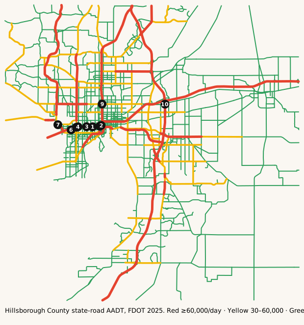
The busiest roads
Ranked by average daily vehicles. Bring snacks for anything near the top.
| Corridor | Avg AADT | Peak segment | Miles | K |
|---|---|---|---|---|
| SR-60 | 186,818 | 203,000 | 1.7 | 9.0% |
| I-4 | 166,747 | 253,000 | 32.5 | 8.4% |
| I-75 | 134,490 | 186,000 | 39.9 | 9.0% |
| I-275 | 120,662 | 190,000 | 15.9 | 8.3% |
| I-275 NB TO I-4 EB | 83,000 | 83,000 | 0.3 | 9.0% |
| VETERANS EXPWY | 81,507 | 107,090 | 15.3 | 9.0% |
| SELMON EXPY | 76,314 | 106,000 | 14.1 | 8.2% |
| I-4 WB TO I-275 SB | 72,500 | 72,500 | 0.5 | 9.0% |
Formula: Avg AADT = Σ(segment AADT × segment miles) ÷ Σ(segment miles), using FDOT's 2025 AADT segments in Hillsborough County.
Busiest single segments, 2025:
| Road | From → To | AADT |
|---|---|---|
| I-4 | Bridge No-100698 → Bridge No-100832 | 253,000 |
| I-4 | Bridge No-100138 → 10320000 NB OFF | 252,000 |
| I-4 | N/A → Bridge No-100698 | 220,000 |
| I-4 | Bridge No-100825 → N/A | 220,000 |
| I-4 | Bridge No-100832 → Bridge No-100138 | 215,500 |
| I-4 | Bridge No-100117 → Bridge No-100817 | 206,000 |
| SR-60 | I-275/SR-93 → SR-60 WB/10140103 | 203,000 |
| I-4 | Bridge No-100817 → Bridge No-100825 | 198,000 |
| I-275 | Bridge No-100204 → Bridge No-100211 | 190,000 |
| I-75 | N/A → Bridge No-100393 | 186,000 |
| I-4 | Bridge No-100115 → Bridge No-100117 | 184,500 |
| I-4 | EAST END BR 150107 → Bridge No-100115 | 184,500 |
AADT is the annual average number of vehicles per day on a segment. High volume isn't the same as congestion: freeways often carry the most because they have the most lanes.
How we know
- FDOT Annual Average Daily Traffic (Roadway Characteristics Inventory; public, "as is").
- Live list: FDOT DIVAS traffic events, Hillsborough County TTC closures. Pulled server-side every 5 minutes. Public FDOT GIS service, no key. FDOT provides data "as is". Public Hillsborough County ArcGIS FeatureServer (TTCPermitsV4), no key. Florida public records / as-is disclaimer. Used for the Tampa page and Tampa Bay master.
- Cameras: FL511 camera list (FDOT). Stills hot-linked from fl511.com; not stored here.
FAQ
What area does this cover?
Hillsborough County, Florida (Tampa). Live incidents come from FDOT's DIVAS event feed filtered to that county.
How often does the live list update?
Every 5 minutes. The page is rebuilt from official feeds server-side; we don't invent counts.
Where do the traffic numbers come from?
FDOT Roadway Characteristics Inventory annual average daily traffic (AADT) for state roads in Hillsborough County, plus FL511 cameras. FDOT provides the data "as is".
Is this for navigation or emergencies?
No. For live routing use FL511 or your maps app. In an emergency call 911.
Last updated: AADT fetched October 27, 2026; page rebuilt October 27, 2026.